
File:MIA - Miami International Airport FAA diagram.png

Original file (2,306 × 1,600 pixels, file size: 446 KB, MIME type: image/png)
| This is a file from the Wikimedia Commons. Information from its description page there is shown below. Commons is a freely licensed media file repository. You can help. |
Summary

|
File:MIA - Miami International Airport FAA diagram.svg is a vector version of this file. It should be used in place of this PNG file when not inferior.
File:MIA - Miami International Airport FAA diagram.png → File:MIA - Miami International Airport FAA diagram.svg
For more information, see Help:SVG. |
 |
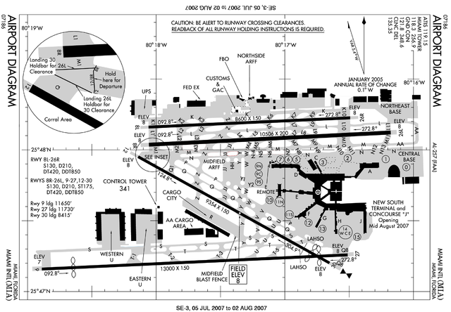
Produced by the National Aeronautical Charting Office (NACO), a department of the Federal Aviation Administration (FAA).
http://www.naco.faa.gov/d-tpp/0711/00257AD.PDF (dead link)
Note: this diagram is updated monthly, and the URL changes accordingly. To find the current version, use the following google search: [1]
Converted from PDF to PNG by Mareklug
on linux using the command:
convert -density 300x300 filename.PDF filename.png
This image has expired
FAA airport maps appear to be valid only for one month. As of November 2009, this map is 2 years old. Hence, you should use the image below.
Licensing
This image or file is a work of a Federal Aviation Administration employee, taken or made as part of that person's official duties. As a work of the U.S. federal government, the image is in the public domain in the United States.
|
 |
File history
Click on a date/time to view the file as it appeared at that time.
| Date/Time | Thumbnail | Dimensions | User | Comment | |
|---|---|---|---|---|---|
| current | 20:53, 19 August 2007 | | 2,306 × 1,600 (446 KB) | Mareklug | {{en|FAA diagram of Miami International Airport (IATA code: MIA, ICAO code: KMIA, FAA code: MIA) in Miami, Florida, USA}} Produced by the National Aeronautical Charting Office (NACO), a department of the [[w:Federal Avia |
File usage
There are no pages that use this file.