
File:Map of Franconia.PNG

Size of this preview: 439 × 599 pixels. Other resolutions: 176 × 240 pixels | 352 × 480 pixels | 563 × 768 pixels | 750 × 1,024 pixels | 1,351 × 1,844 pixels.
Original file (1,351 × 1,844 pixels, file size: 500 KB, MIME type: image/png)
| This is a file from the Wikimedia Commons. Information from its description page there is shown below. Commons is a freely licensed media file repository. You can help. |
Summary
| Description |
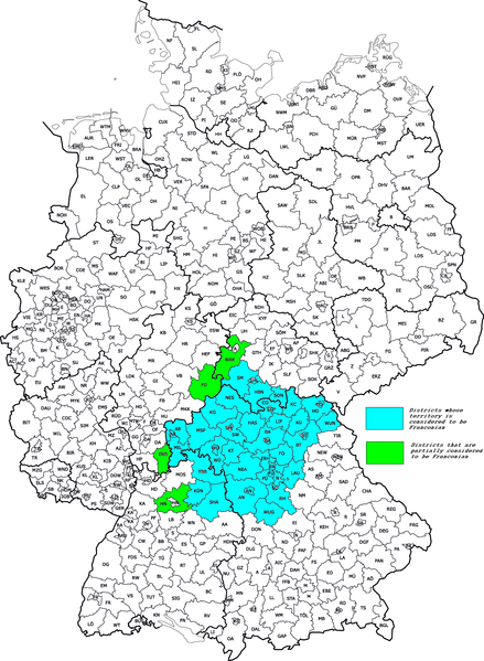
Hrvatski: Okruzi suvremene Frankonije
English: Districts of modern Franconia |
| Date | (UTC) |
| Source |
This file was derived from: |
| Author |
|

| This is a retouched picture, which means that it has been digitally altered from its original version. Modifications: painting all areas that belong to Franconia. The original can be viewed here: Franconia details.png:
|
Licensing
This file is licensed under the Creative Commons Attribution-Share Alike 3.0 Unported license.
- You are free:
- to share – to copy, distribute and transmit the work
- to remix – to adapt the work
- Under the following conditions:
- attribution – You must give appropriate credit, provide a link to the license, and indicate if changes were made. You may do so in any reasonable manner, but not in any way that suggests the licensor endorses you or your use.
- share alike – If you remix, transform, or build upon the material, you must distribute your contributions under the same or compatible license as the original.
Original upload log
This image is a derivative work of the following images:
- File:Kfz-Kennzeichen_Deutschlands.png licensed with Cc-by-2.5
- 2011-07-30T17:48:54Z NordNordWest 1351x1844 (440007 Bytes) update
- 2008-08-01T12:04:02Z NordNordWest 1351x1844 (440344 Bytes) Kreisreform Sachsen August 2008
- 2007-08-03T08:19:47Z Fremantleboy 1351x1844 (394175 Bytes)
- 2007-08-03T08:18:22Z Fremantleboy 2814x3841 (1138459 Bytes)
- 2007-06-28T16:19:03Z Fremantleboy 1351x1844 (395329 Bytes)
- 2007-05-25T19:13:46Z Fremantleboy 2814x3841 (1145080 Bytes) == Beschreibung == {{Information |Description=Map of German license plates |Source=own work on base of image:Landkreise.svg by [[user:DieBuche]] |Date=24. May 2007 - 24. Mai 2007 |Author=[[user:fremantleboy]] M. Stadthaus |Pe
- 2007-05-24T15:56:15Z Fremantleboy 2814x3841 (1139626 Bytes) {{Information |Description=Map of German license plates |Source=own work - selbst erstellt |Date=24. May 2007 - 24. Mai 2007 |Author=[[user:fremantleboy]] M. Stadthaus |Permission= |other_versions=[Image:Kfz-Kennzeichen_Deuts
- File:Franconia_details.png licensed with Cc-by-sa-3.0
- 2009-02-27T22:53:45Z Mikmaq 1180x825 (545458 Bytes) {{Information |Description=Cities and towns in Franconia |Source=Image (Map) made by [[User:Mikmaq|Mikmaq]] |Date=2009-02-27 |Author=[[User:Mikmaq|Mikmaq]] |Permission=CC-BY-SA-3.0 |other_versions=[[Image:Franken_Region_Detai
Uploaded with derivativeFX
File history
Click on a date/time to view the file as it appeared at that time.
| Date/Time | Thumbnail | Dimensions | User | Comment | |
|---|---|---|---|---|---|
| current | 09:05, 28 May 2012 | | 1,351 × 1,844 (500 KB) | Quahadi | == {{int:filedesc}} == {{Information |Description={{hr|Okruzi suvremene Frankonije}} {{en|Districts of modern Franconia}} |Source={{Derived from|Kfz-Kennzeichen_Deutschlands.png|Franconia_details.png|display=50}} |Date=2012-05-06 07:56 (UTC) |Author=*[... |
| 08:02, 6 May 2012 |  | 1,351 × 1,844 (500 KB) | Quahadi | == {{int:filedesc}} == {{Information |Description={{hr|Okruzi suvremene Frankonije}} {{en|Districts of modern Franconia}} |Source={{Derived from|Kfz-Kennzeichen_Deutschlands.png|Franconia_details.png|display=50}} |Date=2012-05-06 07:56 (UTC) |Author=*[... |
File usage
The following page uses this file:
Global file usage
The following other wikis use this file:
- Usage on als.wikipedia.org
- Usage on ar.wikipedia.org
- Usage on bg.wikipedia.org
- Usage on ca.wikipedia.org
- Usage on cs.wikipedia.org
- Usage on de.wikipedia.org
- Usage on en.wikipedia.org
- Usage on eo.wikipedia.org
- Usage on es.wikipedia.org
- Usage on eu.wikipedia.org
- Usage on fr.wikipedia.org
- Usage on gl.wikipedia.org
- Usage on he.wikipedia.org
- Usage on hr.wikipedia.org
- Usage on hu.wikipedia.org
- Usage on id.wikipedia.org
- Usage on it.wikipedia.org
- Usage on it.wikivoyage.org
- Usage on ja.wikipedia.org
- Usage on ka.wikipedia.org
- Usage on ko.wikipedia.org
- Usage on lv.wikipedia.org
- Usage on mk.wikipedia.org
- Usage on nl.wikipedia.org
- Usage on pl.wiktionary.org
- Usage on ru.wikipedia.org
- Usage on sl.wikipedia.org
- Usage on sv.wikipedia.org
- Usage on th.wikipedia.org
- Usage on www.wikidata.org
- Usage on zh.wikipedia.org