
File:Mapa Virreinato Nueva España.png

Size of this preview: 782 × 600 pixels. Other resolutions: 313 × 240 pixels | 626 × 480 pixels | 939 × 720 pixels.
Original file (939 × 720 pixels, file size: 72 KB, MIME type: image/png)
| This is a file from the Wikimedia Commons. Information from its description page there is shown below. Commons is a freely licensed media file repository. You can help. |

|
File:Mapa del Virreinato de la Nueva España (1794).svg is a vector version of this file. It should be used in place of this PNG file when not inferior.
File:Mapa Virreinato Nueva España.png → File:Mapa del Virreinato de la Nueva España (1794).svg
For more information, see Help:SVG. |
.svg) |
Summary
| Description |
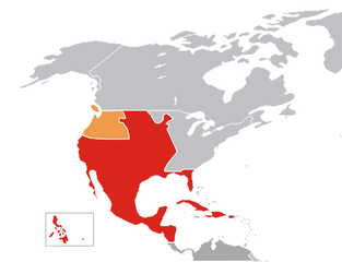
English: Map of Viceroyalty of New Spain Español: Mapa del Virreinato de la Nueva España (siglo XVIII) |
| Date | Unknown date |
| Source | Own work |
| Author | Jluisrs |
Licensing
| I, the copyright holder of this work, release this work into the public domain. This applies worldwide. In some countries this may not be legally possible; if so: I grant anyone the right to use this work for any purpose, without any conditions, unless such conditions are required by law. |
File history
Click on a date/time to view the file as it appeared at that time.
| Date/Time | Thumbnail | Dimensions | User | Comment | |
|---|---|---|---|---|---|
| current | 21:03, 22 April 2007 | | 939 × 720 (72 KB) | Jluisrs | {{Information |Description= Map of Viceroyalty of New Spain / Mapa del Virreinato de la Nueva España (siglo XVIII) |Source=self-made |Date= 22-04-2007 |Author= User:Jluisrs }} |
File usage
There are no pages that use this file.