
File:Polish Corridor.PNG
Size of this preview: 800 × 518 pixels. Other resolutions: 320 × 207 pixels | 640 × 414 pixels | 929 × 601 pixels.
Original file (929 × 601 pixels, file size: 15 KB, MIME type: image/png)
| This is a file from the Wikimedia Commons. Information from its description page there is shown below. Commons is a freely licensed media file repository. You can help. |
| Description |
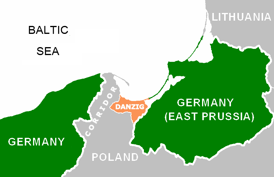
English: Interwar Danzig corridor, created in the post-WW1 settlement so that Poland would not be landlocked or completely dependent on German ports |
| Date | 25 December 2007 (original upload date) |
| Source | Transferred from en.wikipedia to Commons by Broadbeer using CommonsHelper. |
| Author | Space Cadet at English Wikipedia |
| Other versions | العربيَّة |
Licensing
Space Cadet at English Wikipedia, the copyright holder of this work, hereby publishes it under the following licenses:

|
Permission is granted to copy, distribute and/or modify this document under the terms of the GNU Free Documentation License, Version 1.2 or any later version published by the Free Software Foundation; with no Invariant Sections, no Front-Cover Texts, and no Back-Cover Texts. A copy of the license is included in the section entitled GNU Free Documentation License. |
This file is licensed under the Creative Commons Attribution-Share Alike 3.0 Unported, 2.5 Generic, 2.0 Generic and 1.0 Generic license.
Attribution: Space Cadet at English Wikipedia
- You are free:
- to share – to copy, distribute and transmit the work
- to remix – to adapt the work
- Under the following conditions:
- attribution – You must give appropriate credit, provide a link to the license, and indicate if changes were made. You may do so in any reasonable manner, but not in any way that suggests the licensor endorses you or your use.
- share alike – If you remix, transform, or build upon the material, you must distribute your contributions under the same or compatible license as the original.
You may select the license of your choice.
Original upload log
The original description page was here. All following user names refer to en.wikipedia.
- 2007-12-25 16:53 Space Cadet 929×601× (39512 bytes) existing map with dutch names translated into English
File history
Click on a date/time to view the file as it appeared at that time.
| Date/Time | Thumbnail | Dimensions | User | Comment | |
|---|---|---|---|---|---|
| current | 13:15, 15 July 2014 | | 929 × 601 (15 KB) | AnonMoos | increasing PNG compression |
| 18:39, 13 July 2014 |  | 929 × 601 (40 KB) | Victor falk~commonswiki | baltic sea | |
| 22:44, 15 October 2008 |  | 929 × 601 (39 KB) | File Upload Bot (Magnus Manske) | {{BotMoveToCommons|en.wikipedia}} {{Information |Description={{en|existing map with Dutch names translated into English}} |Source=Transferred from [http://en.wikipedia.org en.wikipedia]; transferred to Commons by User:Broadbeer using [http://tools.wi |
File usage
The following page uses this file:
Global file usage
The following other wikis use this file:
- Usage on af.wikipedia.org
- Usage on ar.wikipedia.org
- Usage on az.wikipedia.org
- Usage on bg.wikipedia.org
- Usage on ca.wikipedia.org
- Usage on cy.wikipedia.org
- Usage on da.wikipedia.org
- Usage on el.wikipedia.org
- Usage on en.wikipedia.org
- Usage on eo.wikipedia.org
- Usage on eo.wikiquote.org
- Usage on eu.wikipedia.org
- Usage on fa.wikipedia.org
- Usage on he.wikipedia.org
- Usage on hy.wikipedia.org
- Usage on id.wikipedia.org
- Usage on ja.wikipedia.org
- Usage on ko.wikipedia.org
- Usage on ms.wikipedia.org
- Usage on pnb.wikipedia.org
- Usage on pt.wikipedia.org
- Usage on ro.wikipedia.org
- Usage on sh.wikipedia.org
- Usage on sv.wikipedia.org
- Usage on th.wikipedia.org
- Usage on uk.wikipedia.org
- Usage on ur.wikipedia.org
- Usage on vi.wikipedia.org
- Usage on www.wikidata.org
- Usage on zh.wikipedia.org