
File:Pondbridge Hill, Liskeard - geograph.org.uk - 1137549.jpg
Size of this preview: 450 × 600 pixels. Other resolutions: 180 × 240 pixels | 480 × 640 pixels.
Original file (480 × 640 pixels, file size: 68 KB, MIME type: image/jpeg)
| This is a file from the Wikimedia Commons. Information from its description page there is shown below. Commons is a freely licensed media file repository. You can help. |
Summary
| Description |
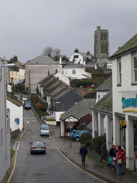
English: Pondbridge Hill, Liskeard A short hill seen from the junction with Bay Tree Hill and Fore Street, and which continues up the far slope as Cannon Hill. "Unfortunately this view is marred by the gaping holes of demolished buildings and inappropriately scaled and detailed modern developments." http://www.historic-cornwall.org.uk/csus/towns/liskeard/csus_liskeard_report_2005R049.pdf .
On the right is the modern (1902) tower of St Martin's Church. |
| Date | |
| Source | From geograph.org.uk |
| Author | Derek Harper |
| Attribution (required by the license) | Derek Harper / Pondbridge Hill, Liskeard / |
| Camera location | | View this and other nearby images on: OpenStreetMap |
|---|
_heading:112.00&language=en)
| Object location | | View this and other nearby images on: OpenStreetMap |
|---|
_heading:112.00&language=en)
Licensing

|
This image was taken from the Geograph project collection. See this photograph's page on the Geograph website for the photographer's contact details. The copyright on this image is owned by Derek Harper and is licensed for reuse under the Creative Commons Attribution-ShareAlike 2.0 license.
|
This file is licensed under the Creative Commons Attribution-Share Alike 2.0 Generic license.
Attribution: Derek Harper
- You are free:
- to share – to copy, distribute and transmit the work
- to remix – to adapt the work
- Under the following conditions:
- attribution – You must give appropriate credit, provide a link to the license, and indicate if changes were made. You may do so in any reasonable manner, but not in any way that suggests the licensor endorses you or your use.
- share alike – If you remix, transform, or build upon the material, you must distribute your contributions under the same or compatible license as the original.
File history
Click on a date/time to view the file as it appeared at that time.
| Date/Time | Thumbnail | Dimensions | User | Comment | |
|---|---|---|---|---|---|
| current | 04:30, 25 February 2011 | | 480 × 640 (68 KB) | GeographBot | == {{int:filedesc}} == {{Information |description={{en|1=Pondbridge Hill, Liskeard A short hill seen from the junction with Bay Tree Hill and Fore Street, and which continues up the far slope as Cannon Hill. "Unfortunately this view is marred by the gapin |
File usage
The following page uses this file:
Global file usage
The following other wikis use this file: