
File:Rodrigues Island topographic-zones map-fr.svg

Size of this PNG preview of this SVG file: 637 × 600 pixels. Other resolutions: 255 × 240 pixels | 510 × 480 pixels | 816 × 768 pixels | 1,088 × 1,024 pixels | 2,176 × 2,048 pixels | 1,700 × 1,600 pixels.
Original file (SVG file, nominally 1,700 × 1,600 pixels, file size: 989 KB)
| This is a file from the Wikimedia Commons. Information from its description page there is shown below. Commons is a freely licensed media file repository. You can help. |

| Description |
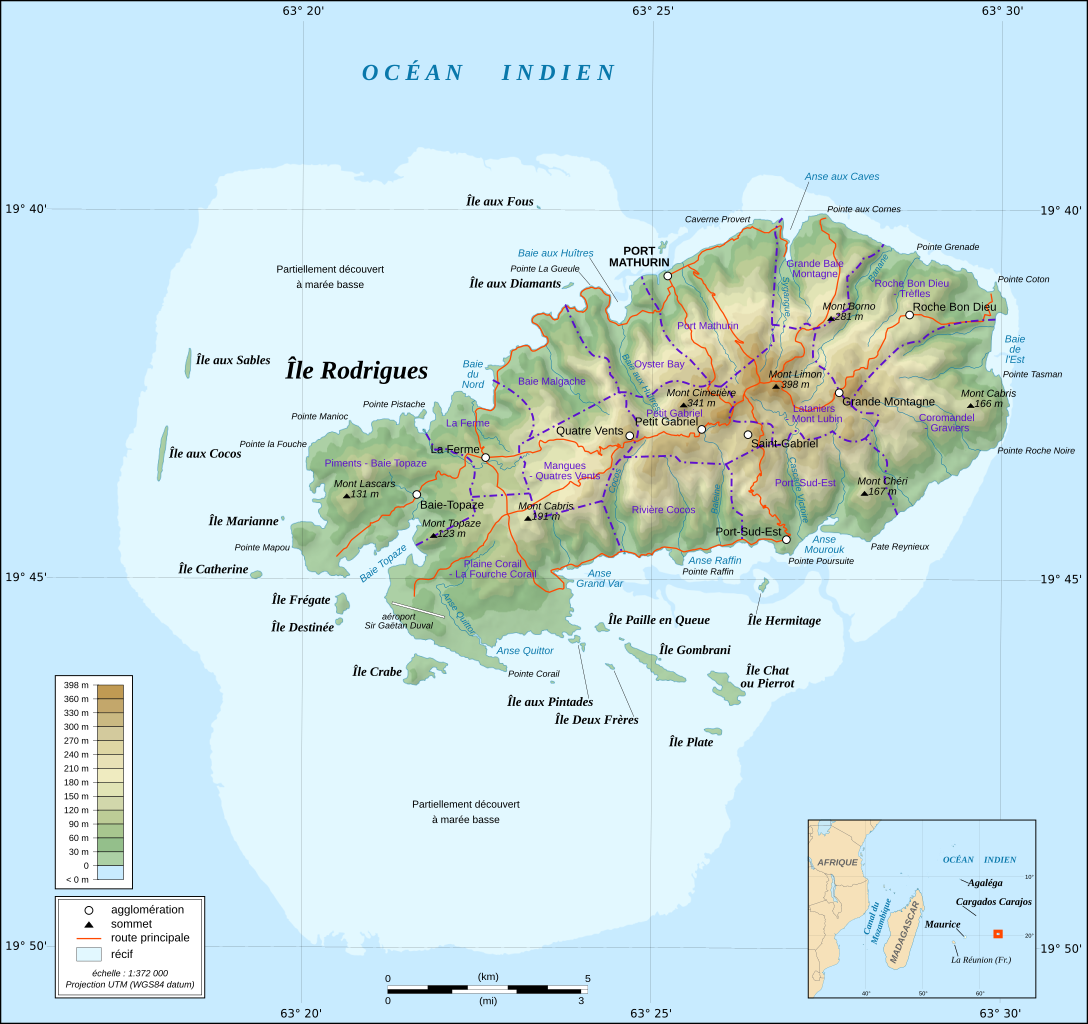
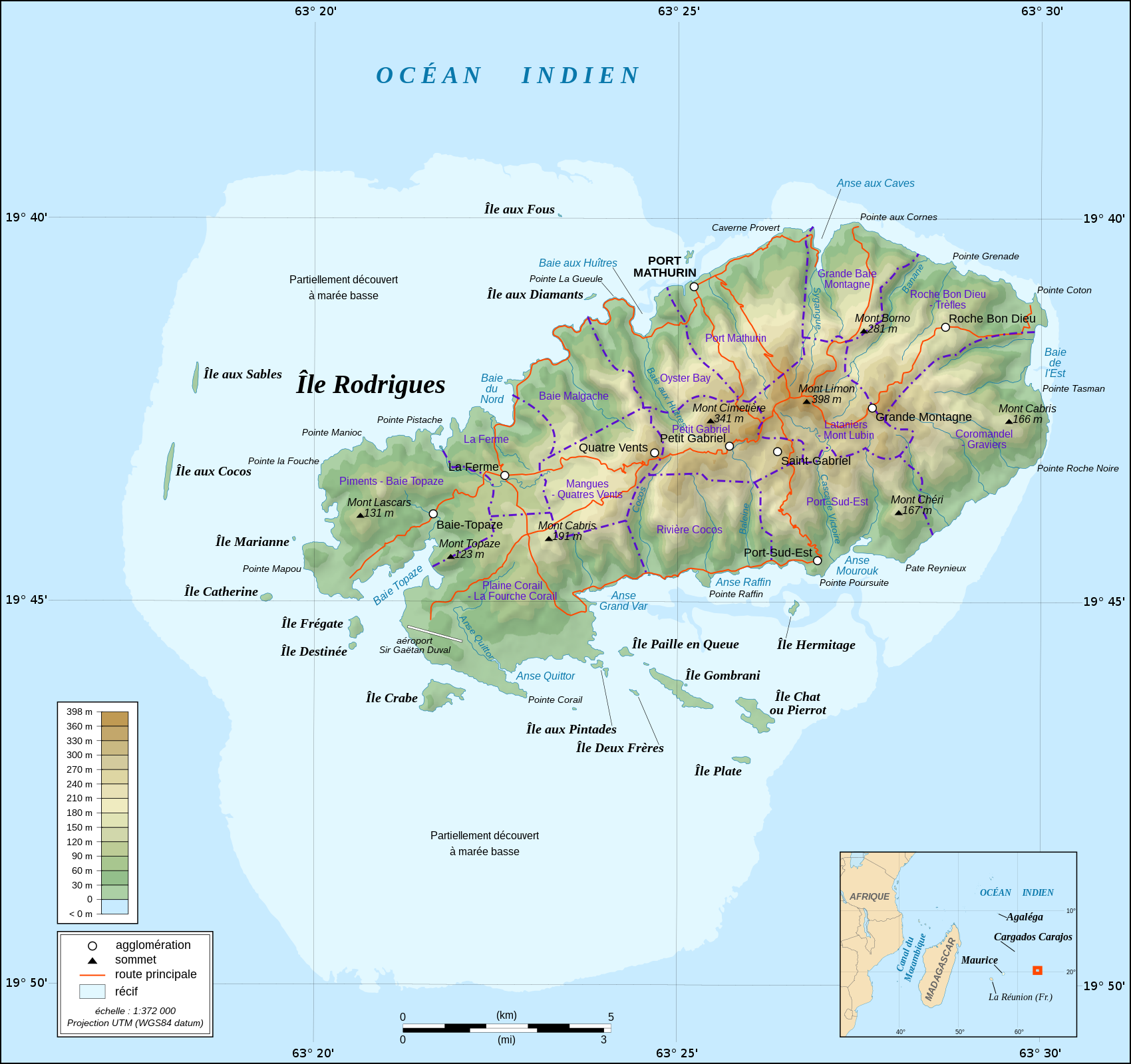
Deutsch: Zonenkarte der Insel Rodrigues
English: Topographic map in French of Rodrigues Island, Mauritius Scale : 1:372,000 (accuracy : about 93 m) ; Printing size : 7.79 x 7.33 cm ; Note : The background map is a raster image embedded in the SVG file. Français : Carte topographique en français de l'île de Rodrigues, Maurice ; UTM projection ; WGS84 datum ; shaded relief (composite image of N-W, W and N lightning positions) ;Échelle : 1:372 000 (précision : environ 93 m) ; Taille d'impression : 7,79 x 7,33 cm ; Note : Le fond de carte est une image bitmap embarquée dans le fichier SVG. Geographic limits of the map: *West : 63° 15' 34.66" E *East : 63° 31' 14.68" E *North : 19° 37' 09.97" S *South : 19° 51' 02.05" S |
| Date | (UTC) |
| Source | |
| Author |
|
| Other versions |
Derivative works of this file: |
| This is a retouched picture, which means that it has been digitally altered from its original version. Modifications: fusion des 2 cartes. The original can be viewed here: Rodrigues Island topographic map-fr.svg:
|
This file is licensed under the Creative Commons Attribution-Share Alike 3.0 Unported license.
- You are free:
- to share – to copy, distribute and transmit the work
- to remix – to adapt the work
- Under the following conditions:
- attribution – You must give appropriate credit, provide a link to the license, and indicate if changes were made. You may do so in any reasonable manner, but not in any way that suggests the licensor endorses you or your use.
- share alike – If you remix, transform, or build upon the material, you must distribute your contributions under the same or compatible license as the original.
Original upload log
This image is a derivative work of the following images:
- File:Rodrigues_Zonenkarte_de.png licensed with Cc-by-sa-3.0
- 2010-03-02T14:15:57Z Vuxi 1284x1209 (562056 Bytes) + Schriftzug
- 2010-03-01T21:56:33Z Vuxi 1284x1209 (558361 Bytes) einige Orte
- 2010-02-27T21:36:06Z Vuxi 1284x1209 (552183 Bytes) + Namen der Zonen + Orte - Berge
- 2010-02-26T10:45:31Z Vuxi 1284x1209 (536481 Bytes) {{Information |Description={{de|1=Zonenkarte der Insel Rodrigues}} |Source={{own}} |Author=[[User:Vuxi|Vuxi]] |Date= |Permission= |other_versions= }} topographic map:[[:File:Rodrigues Island topographic map-de.svg]], borders:
- File:Rodrigues_Island_topographic_map-fr.svg licensed with Cc-by-sa-3.0,2.5,2.0,1.0, GFDL
- 2008-09-06T02:29:37Z Sting 1700x1600 (1025524 Bytes) Adding roads and other labels ; new standard colors
- 2008-05-14T03:46:05Z Sting 1700x1600 (782832 Bytes) == Summary == {{Location|19|43|00|S|63|25|00|E|scale:200000}} {{Information |Description={{en|Topographic map in French of [[:en:Rodrigues (island)|Rodrigues Island]], [[:en:Mauritius|Mauritius]]}} {{fr|Carte topographique e
Uploaded with derivativeFX
File history
Click on a date/time to view the file as it appeared at that time.
| Date/Time | Thumbnail | Dimensions | User | Comment | |
|---|---|---|---|---|---|
| current | 00:36, 25 June 2022 | | 1,700 × 1,600 (989 KB) | Blua lago | File uploaded using svgtranslate tool (https://svgtranslate.toolforge.org/). Added translation for hu. |
| 08:27, 11 August 2010 |  | 1,700 × 1,600 (970 KB) | M0tty | {{Information |Description={{de|1=Zonenkarte der Insel Rodrigues}} {{en|Topographic map in French of Rodrigues Island, Mauritius<br/>Scale : 1:372,000 (accuracy : about 93 m) ; Printing size : 7.79 x 7.33 cm ;< |
File usage
The following page uses this file:
Global file usage
The following other wikis use this file:
- Usage on fr.wikipedia.org
- Usage on nl.wikipedia.org
- Usage on uk.wikipedia.org
- Usage on zh-yue.wikipedia.org