
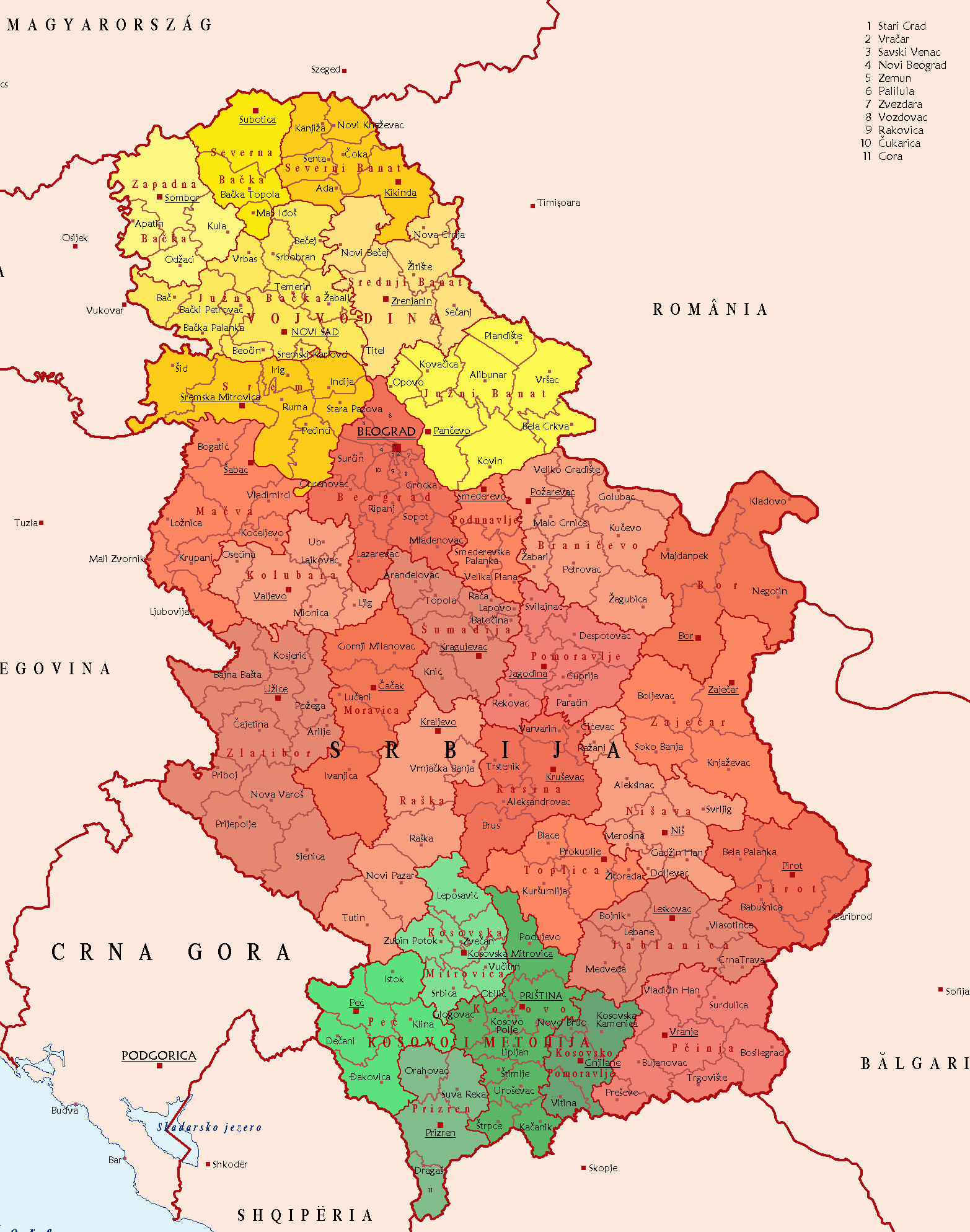
File:SerbiaPoliticalDivision.png
Size of this preview: 472 × 600 pixels. Other resolutions: 189 × 240 pixels | 378 × 480 pixels | 604 × 768 pixels | 806 × 1,024 pixels | 1,565 × 1,988 pixels.
Original file (1,565 × 1,988 pixels, file size: 186 KB, MIME type: image/png)
| This is a file from the Wikimedia Commons. Information from its description page there is shown below. Commons is a freely licensed media file repository. You can help. |
Summary
| Description |
English: Political Division of Serbia Deutsch: Politische Gliederung Serbiens Polski: Podział administracyjny Republiki Serbii . |
| Source | Taken from German Wikipedia: de:File:SCG Politische Gliederung2.png. |
| Author | CCGavranCC at the German Wikipedia |
| Other versions |
  .png) |
Licensing
| |
This work has been released into the public domain by its author, CCGavranCC, at the English Wikipedia project. This applies worldwide. In case this is not legally possible: |
File history
Click on a date/time to view the file as it appeared at that time.
| Date/Time | Thumbnail | Dimensions | User | Comment | |
|---|---|---|---|---|---|
| current | 04:44, 26 March 2018 | | 1,565 × 1,988 (186 KB) | Yann | Reverted to version as of 18:02, 15 June 2017 (UTC) |
| 14:32, 25 March 2018 |  | 1,565 × 1,988 (187 KB) | Hakuli | Reverted to version as of 17:00, 15 June 2017 (UTC) | |
| 18:02, 15 June 2017 |  | 1,565 × 1,988 (186 KB) | Кликери | Reverted to version as of 22:45, 27 January 2015 (UTC) | |
| 17:00, 15 June 2017 |  | 1,565 × 1,988 (187 KB) | Hakuli | Reverted to version as of 13:57, 22 January 2015 (UTC) | |
| 22:45, 27 January 2015 |  | 1,565 × 1,988 (186 KB) | Anastan | mapalready exist, File:Districts and Municipalities of Serbia (without Kosovo).png | |
| 14:59, 27 January 2015 |  | 1,565 × 1,988 (187 KB) | Mapclean | incorrect borders | |
| 19:23, 24 January 2015 |  | 1,565 × 1,988 (186 KB) | Anastan | upload new map, restore original | |
| 13:57, 22 January 2015 |  | 1,565 × 1,988 (187 KB) | Mapclean | Borders | |
| 21:46, 1 February 2014 |  | 1,565 × 1,988 (186 KB) | BokicaK | cropped | |
| 16:16, 5 June 2006 |  | 2,089 × 2,538 (300 KB) | Bjarki S | Taken from German Wikipedia: de:Bild:SCG Politische Gliederung2.png. In public domain. {{pd}} |
File usage
The following 2 pages use this file:
Global file usage
The following other wikis use this file:
- Usage on ar.wikipedia.org
- Usage on ast.wikipedia.org
- Usage on be-tarask.wikipedia.org
- Usage on bg.wikipedia.org
- Usage on bn.wikipedia.org
- Usage on ca.wikipedia.org
- Usage on csb.wikipedia.org
- Usage on cs.wikipedia.org
- Usage on de.wikipedia.org
- Usage on en.wikipedia.org
- Usage on es.wikipedia.org
- Usage on fr.wikipedia.org
- Usage on hr.wikipedia.org
- Usage on hu.wikipedia.org
- Usage on is.wikipedia.org
- Usage on ja.wikipedia.org
- Usage on ku.wikipedia.org
- Usage on lt.wikipedia.org
- Usage on pl.wikipedia.org
- Usage on pl.wikivoyage.org
- Usage on ro.wikipedia.org
- Usage on ru.wiktionary.org
- Usage on sco.wikipedia.org
- Usage on sh.wikipedia.org
- Usage on si.wikipedia.org
- Usage on sk.wikipedia.org
- Usage on sl.wikipedia.org
- Usage on sr.wikipedia.org
- Usage on trv.wikipedia.org
- Usage on uk.wikipedia.org
View more global usage of this file.