
File:Tasmanian Devil Tumour Map.png
No higher resolution available.
Tasmanian_Devil_Tumour_Map.png (288 × 202 pixels, file size: 12 KB, MIME type: image/png)
| This is a file from the Wikimedia Commons. Information from its description page there is shown below. Commons is a freely licensed media file repository. You can help. |
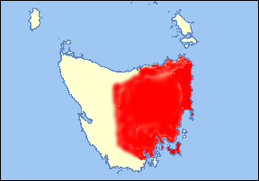
| Description | Map of Tasmania showing the spread of facial tumours in the Tasmanian Devil population. Based on data from the Department of Primary Industries and Water, Tasmanian Government. February 2008. Tumour area shown in red. |
| Date | (UTC) |
| Source | |
| Author |
User:Peterdownunder
|
| This is a retouched picture, which means that it has been digitally altered from its original version. The original can be viewed here: Tasmania location map.svg: File:Tasmania location map.svg. Modifications made by Peterdownunder.
|
I, the copyright holder of this work, hereby publish it under the following licenses:
This file is licensed under the Creative Commons Attribution-Share Alike 2.5 Generic, 2.0 Generic and 1.0 Generic license.
- You are free:
- to share – to copy, distribute and transmit the work
- to remix – to adapt the work
- Under the following conditions:
- attribution – You must give appropriate credit, provide a link to the license, and indicate if changes were made. You may do so in any reasonable manner, but not in any way that suggests the licensor endorses you or your use.
- share alike – If you remix, transform, or build upon the material, you must distribute your contributions under the same or compatible license as the original.
You may select the license of your choice.
Original upload log
This image is a derivative work of the following images:
- File:Tasmania_location_map.svg licensed with Cc-by-sa-2.5,2.0,1.0, Cc-by-sa-2.5,2.0,1.0
- 2006-01-30T14:44:18Z Diceman 288x202 (3172 Bytes) border
- 2006-01-30T14:24:12Z Diceman 288x202 (3152 Bytes) widescreen
- 2006-01-30T13:55:49Z Diceman 244x202 (3148 Bytes) non-wikipedia standard colours
- 2006-01-30T13:30:21Z Diceman 244x202 (3140 Bytes) Tasmania location map. [[Category:Tasmania]] [[Category:Maps of Australian states]]
Uploaded with derivativeFX
File history
Click on a date/time to view the file as it appeared at that time.
| Date/Time | Thumbnail | Dimensions | User | Comment | |
|---|---|---|---|---|---|
| current | 06:23, 17 January 2009 | | 288 × 202 (12 KB) | Peterdownunder | {{Information |Description=Map of Tasmania showing the spread of facial tumours in the Tasmanian Devil population. Based on data from the Department of Primary Industries and Water, Tasmanian Government. February 2008. Tumour area shown in red. |Source=*[ |
File usage
The following page uses this file:
Global file usage
The following other wikis use this file:
- Usage on fi.wikipedia.org