
File:Volcanic system of Iceland-Map-fr.svg

Size of this PNG preview of this SVG file: 726 × 588 pixels. Other resolutions: 296 × 240 pixels | 593 × 480 pixels | 948 × 768 pixels | 1,264 × 1,024 pixels | 2,529 × 2,048 pixels.
Original file (SVG file, nominally 726 × 588 pixels, file size: 355 KB)
| This is a file from the Wikimedia Commons. Information from its description page there is shown below. Commons is a freely licensed media file repository. You can help. |
Summary
| Description |
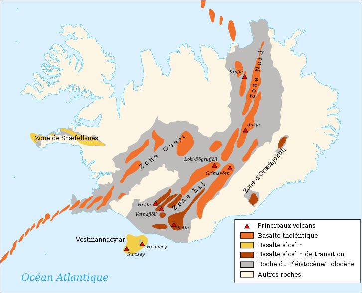
Français : Carte en français du système volcanique de l'Islande
English: Map in french of the volcanic system of Iceland
Español: Mapa del sistema volcánicode Islandia en francés |
| Date | |
| Source | Own work made with inkscape from Image:Blank map of Iceland.svg and this document p.12 and for the volcanoes this map from USGS |
| Author | Pinpin |
| Other versions |
Derivative works of this file: |
This W3C-unspecified vector image was created with Inkscape .

|
This SVG file contains embedded text that can be translated into your language, using any capable SVG editor, text editor or the SVG Translate tool. For more information see: About translating SVG files. |
Licensing
I, the copyright holder of this work, hereby publish it under the following licenses:

|
Permission is granted to copy, distribute and/or modify this document under the terms of the GNU Free Documentation License, Version 1.2 or any later version published by the Free Software Foundation; with no Invariant Sections, no Front-Cover Texts, and no Back-Cover Texts. A copy of the license is included in the section entitled GNU Free Documentation License. |
This file is licensed under the Creative Commons Attribution-Share Alike 3.0 Unported, 2.5 Generic, 2.0 Generic and 1.0 Generic license.
- You are free:
- to share – to copy, distribute and transmit the work
- to remix – to adapt the work
- Under the following conditions:
- attribution – You must give appropriate credit, provide a link to the license, and indicate if changes were made. You may do so in any reasonable manner, but not in any way that suggests the licensor endorses you or your use.
- share alike – If you remix, transform, or build upon the material, you must distribute your contributions under the same or compatible license as the original.
You may select the license of your choice.
File history
Click on a date/time to view the file as it appeared at that time.
| Date/Time | Thumbnail | Dimensions | User | Comment | |
|---|---|---|---|---|---|
| current | 03:22, 24 December 2022 | | 726 × 588 (355 KB) | Wikijahnn | File uploaded using svgtranslate tool (https://svgtranslate.toolforge.org/). Added translation for ca. |
| 03:21, 24 December 2022 |  | 726 × 588 (355 KB) | Wikijahnn | File uploaded using svgtranslate tool (https://svgtranslate.toolforge.org/). Added translation for ca. | |
| 15:35, 4 August 2019 |  | 726 × 588 (345 KB) | Rohieb | transform "Zone de Snæfellsnes" from a path back into a translatable string | |
| 15:30, 4 August 2019 |  | 726 × 588 (346 KB) | Rohieb | transform "Zone de Snæfellsnes" back from a path into a translatable string | |
| 13:04, 16 June 2011 |  | 726 × 588 (362 KB) | Lanredec | Correction Laki-Fogrufjoll -> Loki-Fögrufjöll | |
| 17:48, 5 March 2008 |  | 726 × 588 (362 KB) | Pinpin | ||
| 17:56, 4 March 2008 |  | 726 × 588 (362 KB) | Pinpin | ||
| 17:51, 4 March 2008 |  | 726 × 588 (361 KB) | Pinpin | +volcanoes | |
| 10:42, 3 March 2008 |  | 726 × 588 (348 KB) | Pinpin | {{Information |Description={{fr|Carte en français du système volcanique de l'Islande}} {{en|Map in french of the volcanic system of Iceland}} |Source=Own work made with inkscape from Image:Blank map of Iceland.svg and [http://www.surtsey.is/SRS_pub |
File usage
There are no pages that use this file.
Global file usage
The following other wikis use this file:
- Usage on bg.wikinews.org
- Usage on fr.wikipedia.org
- Islande
- Liste des volcans d'Islande
- Herðubreið
- Kverkfjöll
- Krafla
- Katla
- Eldfell
- Hekla
- Brennisteinsalda
- Bláhnúkur
- Snæfellsjökull
- Eldgjá
- Grímsvötn
- Krýsuvík
- Ok (volcan)
- Tindfjöll
- Kerlingarfjöll
- Géographie de l'Islande
- Þingvellir
- Catégorie:Volcan en Islande
- Hverfjall
- Surtsey
- Kolbeinsey
- Îles Vestmann
- Hengill
- Discussion Wikipédia:Wikiconcours/mars 2008/Équipes/Équipe 5
- Helgafell
- Eldey
- Hveravellir
- Modèle:Palette Volcans d'Islande
- Bárðarbunga
- Ljósufjöll
- Esjufjöll
- Surtla
- Syrtlingur
- Jólnir
- Öræfajökull (volcan)
- Torfajökull
- Vatnafjöll
- Eyjafjöll
- Énergie en Islande
- Géologie de l'Islande
- Lakagígar
- Askja
- Région volcanique d'Islande
- Þeistareykir
- Þeistareykjarbunga
- Fremrinámur
View more global usage of this file.