Korosten
Appearance
Korosten
Коростень | |
|---|---|
City | |
| Korosten | |
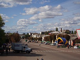
 Main street of Korosten | |
|
| |
| Coordinates: 50°57′N 28°38′E / 50.950°N 28.633°E | |
| Country | |
| Oblast | |
| Raion | Korosten Raion |
| First mentioned | AD 705[source?] |
| Charter granted | 1589 |
| City Status | 1 January 1926[1][2] |
| City council | Korosten City Council |
| Government | |
| • Mayor | Volodymyr Moskalenko |
| Area | |
| • Total | 42.31 km2 (16.34 sq mi) |
| Elevation | 171 m (561 ft) |
| Population (2022) | |
| • Total | 61,496 |
| • Density | 1,500/km2 (3,800/sq mi) |
| Time zone | UTC+2 (EET) |
| • Summer (DST) | UTC+3 (EEST) |
| Postal code | 01xxx–04xxx |
| Area code | +380 44 |
| FIPS code | UP27 |
| Vehicle registration plate | AМ |
| Website | Official website |
Korosten (Ukrainian: Ко́ростень, pronounced [ˈkɔrostenʲ]; historically also Iskorosten Іскоростень) is a historic city and a big transport hub in Zhytomyr Oblast (province). It is in northern Ukraine. It is on the Uzh River. Korosten is the administrative center of the Korosten Raion (district). As of January 2022 its population was approximately 61,496.[3]
References
[change | change source]- ↑ Korosten // Big Encyclopedic Dictionary (in 2 vols.). / editorial board, ch. ed. A.M. Prokhorov. volume 1. M., "Soviet Encyclopedia", 1991. p. 633
- ↑ http://korosten.osp-ua.info/
- ↑ Чисельність наявного населення України на 1 січня 2022 [Number of Present Population of Ukraine, as of January 1, 2022] (PDF) (in Ukrainian and English). Kyiv: State Statistics Service of Ukraine.
Other websites
[change | change source]- (in Ukrainian) Official website
- (in English) Korosten: a small town with a great history Archived 2020-12-09 at the Wayback Machine
- (in Russian) Information on the city of Korosten
- (in Russian) Изучи Коростень @ Ukrainian.Travel
- (in English) Find out Korosten @ Ukrainian.Travel
- (in Ukrainian) Віднайди Коростень @ Ukrainian.Travel


