Lansford, Pennsylvania
Appearance
Lansford, Pennsylvania | |
|---|---|
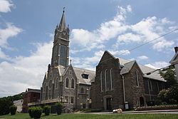
 St. Katharine Drexel Church in the Lansford Historic District in July 2013 | |
 Location of Lansford in Carbon County, Pennsylvania | |
Location of Lansford in Pennsylvania | |
| Coordinates: 40°49′53″N 75°53′0″W / 40.83139°N 75.88333°W | |
| Country | United States |
| State | Pennsylvania |
| County | Carbon |
| Established | c. 1827 along with Coaldale, Pennsylvania |
| Area | |
| • Total | 1.54 sq mi (3.98 km2) |
| • Land | 1.54 sq mi (3.98 km2) |
| • Water | 0.00 sq mi (0.00 km2) |
| Elevation | 1,145 ft (349 m) |
| Population | |
| • Total | 4,141 |
| • Density | 2,695.96/sq mi (1,040.68/km2) |
| Time zone | UTC-5 (EST) |
| • Summer (DST) | UTC-4 (EDT) |
| ZIP Code | 18232 |
| Area codes | 570 |
| FIPS code | 42-41464 |
| Website | www |
Lansford is a county-border borough (town) in Carbon County, Pennsylvania, United States. It is about 37 miles (60 km) northwest of Allentown and 19 miles south of Hazleton.
References
[change | change source]- ↑ "ArcGIS REST Services Directory". United States Census Bureau. Retrieved October 12, 2022.
- ↑ "Profile of General Population and Housing Characteristics: 2020 Demographic Profile Data (DP-1): Lansford borough, Pennsylvania". United States Census Bureau. Retrieved March 12, 2024.


