Mangum, Oklahoma
Appearance
Mangum, Oklahoma | |
|---|---|
 Mangum, Oklahoma Downtown Historic District, September 28, 2014. Courtesy CrimsonEdge | |
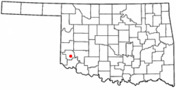
 Location of Mangum, Oklahoma | |
| Coordinates: 34°52′43″N 99°30′14″W / 34.87861°N 99.50389°W | |
| Country | United States |
| State | Oklahoma |
| County | Greer |
| Area | |
| • Total | 1.68 sq mi (4.36 km2) |
| • Land | 1.68 sq mi (4.36 km2) |
| • Water | 0.00 sq mi (0.00 km2) |
| Elevation | 1,608 ft (490 m) |
| Population (2020) | |
| • Total | 2,762 |
| • Density | 1,641.12/sq mi (633.47/km2) |
| Time zone | UTC-6 (Central (CST)) |
| • Summer (DST) | UTC-5 (CDT) |
| ZIP code | 73554 |
| Area code | 580 |
| FIPS code | 40-46050 [3] |
| GNIS feature ID | 2410917[2] |
| Website | City website |
Mangum is a city in Oklahoma in the United States. It is the county seat of Greer County.
Notable people
[change | change source]- Blake Ragsdale Van Leer, former president of Georgia Institute of Technology
- Margaret Avery, actress and singer
- Braden Looper, baseball player
- Gale McArthur, All-American basketball player
- Gary McSpadden, gospel singer and television presenter
References
[change | change source]- ↑ "ArcGIS REST Services Directory". United States Census Bureau. Retrieved September 20, 2022.
- ↑ 2.0 2.1 U.S. Geological Survey Geographic Names Information System: Mangum, Oklahoma
- ↑ "U.S. Census website". United States Census Bureau. Retrieved 2008-01-31.
