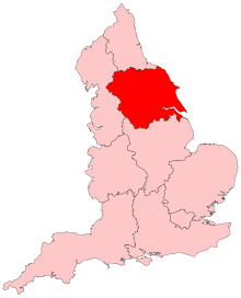
Yorkshire and the Humber
Appearance

Yorkshire and the Humber is one of the regions of England. It covers most of the historic county of Yorkshire, along with the part of northern Lincolnshire that was previously in the administrative area of Humberside (which existed 1974-1996).
The highest point of the region is Whernside, in the Yorkshire Dales, at 737 metres. The largest freshwater lake is Hornsea Mere in the East Riding of Yorkshire.
The population in 2005 was 5,854,357.
Local government
[change | change source]The official region consists of the following subdivisions:
| Map | Ceremonial county | County/ unitary | Districts |
|---|---|---|---|
 |
South Yorkshire * | 1. Sheffield 2. Rotherham 3. Barnsley 4. Doncaster | |
| West Yorkshire * | 5. Wakefield 6. Kirklees 7. Calderdale 8. Bradford 9. Leeds | ||
| North Yorkshire (part only) |
10. North Yorkshire † | Selby Harrogate Craven Richmondshire Hambleton Ryedale Scarborough | |
| 11. York | |||
| East Riding of Yorkshire | 12. East Riding of Yorkshire | ||
| 13. Kingston upon Hull | |||
| Lincolnshire (part only) |
14. North Lincolnshire | ||
| 15. North East Lincolnshire | |||
Key: shire county = † | metropolitan county = *
It was originally called Yorkshire and Humberside, and defined as North Yorkshire, West Yorkshire, South Yorkshire and Humberside.
Other websites
[change | change source]- Government Office for Yorkshire and the Humber Archived 2010-07-22 at the Wayback Machine
- Yorkshire and Humber Assembly Archived 2008-05-01 at the Wayback Machine
