
Bardenas Reales
The Bardenas Reales is a semi-desert natural region, or badlands. It is about 42,000 hectares (100,000 acres) and is located in southeast Navarre (Spain). The soils are made up of clay, chalk and sandstone. They have been eroded by water and wind. This has created a number of shapes, canyons, plateaus, tabular structures and isolated hills, called seamounts. Bardenas lacks urban areas and vegetation is scarce.
Location[change | change source]
The Bardenas is in the southeast of Navarra, bordering Aragon.[1] It is located in the middle of the depression of the Ebro valley[2] at the foot of the mountains of the Yugo and the Zaragoza region of Cinco Villas. It is 45 km (28 mi) from north to south and 24 km (15 mi) east-west and at an altitude ranging between 280 and 659 m (919 and 2,162 ft). Its area is 41,845 hectares (103,400 acres). Limited to sixteen municipalities, of which thirteen are in Navarre and three in the province of Zaragoza.
Gallery[change | change source]
-
 The White Bardena
 -
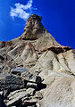
 Cabezo Castildetierra
 -
 A cabezo
 -
 Cabezo Castildetierra
 -
 Eroded gullies
 -
 Ravines
 -
 A U.S. Air Force McDonnell Douglas F-4E-61-MC Phantom II (s/n 74-1630) from the 81st Tactical Fighter Squadron, 52nd Tactical Wing, releasing 18 Mark 82 227 kg bombs over the Bardenas Reales Gunnery Range, Spain, on 25 March 1986
 -
 Demonstration against the Bardenas Reales bombing range in Tudela


.jpg)
References[change | change source]
- ↑ Caroline Trefler, Spain 2009 (New York: Fodor's Travel Publications, Inc., 2009), p. 271
- ↑ Geomorfología y territorio: actas de la IX Reunión Nacional de Geomorfología eds. Augusto Pérez Alberti; Juan López Bedoya (Santiago de Compostela: Universidade de Santiago de Compostela, 2006), p. 656
Other websites[change | change source]
- The landscape of Bardenas Reales
- Las Bardenas Reales (in French)
- Las Bardenas Reales (in Spanish)