Barrington, Rhode Island
Barrington, Rhode Island | |
|---|---|
 Aerial view of Barrington in 2008 | |
 Coat of arms | |
 Location in Bristol County and the state of Rhode Island. | |
 Barrington Location in Rhode Island  Barrington Barrington (the United States) | |
| Coordinates: 41°44′43″N 71°19′5″W / 41.74528°N 71.31806°W | |
| Country | United States |
| State | Rhode Island |
| County | Bristol |
| Settled | 1652 |
| Incorporation (Massachusetts) | November 18, 1717 |
| Annexed to Warren | January 27, 1747 |
| Incorporation (Rhode Island) | June 16, 1770 |
| Area | |
| • Total | 15.4 sq mi (39.9 km2) |
| • Land | 8.4 sq mi (21.8 km2) |
| • Water | 7.0 sq mi (18.1 km2) |
| Elevation | 0 to 50 ft (0 to 15 m) |
| Population | |
| • Total | 17,153 |
| • Density | 2,038/sq mi (786.8/km2) |
| Time zone | UTC−5 (Eastern (EST)) |
| • Summer (DST) | UTC−4 (EDT) |
| ZIP Code | 02806 |
| Area code | 401 |
| FIPS code | 44-05140[3] |
| GNIS feature ID | 1220084[4] |
| Website | barrington |
Barrington (pronounced /ˈbɛərɪŋtɪn/) is a New England town in Bristol County, Rhode Island, United States. The population was 17,153 at the 2020 census.[2]
In July 2005, CNN/Money and Money magazine ranked Barrington sixth on its list of the 100 best places to live in the United States.[5]
References[change | change source]
- ↑ Maximum elevation is at Prince's Hill.
- ↑ 2.0 2.1 "QuickFacts: Barrington town, Bristol County, Rhode Island". U.S. Census Bureau. Retrieved August 3, 2023.
- ↑ "U.S. Census website". United States Census Bureau. Retrieved 2008-01-31.
- ↑ "US Board on Geographic Names". United States Geological Survey. 2007-10-25. Retrieved 2008-01-31.
- ↑ "MONEY Magazine: Best places to live 2005". Money.cnn.com. 2005-05-23. Retrieved 2011-11-27.
Other websites[change | change source]
- Town of Barrington Official Web Site Archived 2007-09-25 at the Wayback Machine
- Town of Barrington Official GIS Maps and Property Information
- Barrington School Department
- The Brendel murders Archived 2008-02-17 at the Wayback Machine.
Municipalities and communities of Bristol County, Rhode Island, United States | ||
|---|---|---|
| Towns | 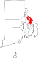 | |