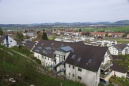
Belp
Belp | |
|---|---|
 | |
| Coordinates: 46°53′N 7°30′E / 46.883°N 7.500°E | |
| Country | Switzerland |
| Canton | Bern |
| District | Bern-Mittelland |
| Government | |
| • Mayor | Rudolf Neuenschwander |
| Area | |
| • Total | 23.3 km2 (9.0 sq mi) |
| Elevation | 521 m (1,709 ft) |
| Population (31 December 2018)[2] | |
| • Total | 11,510 |
| • Density | 490/km2 (1,300/sq mi) |
| Time zone | UTC+01:00 (Central European Time) |
| • Summer (DST) | UTC+02:00 (Central European Summer Time) |
| Postal code(s) | 3123 |
| SFOS number | 0861 |
| Localities | Belpberg, Viehweide, Heitern, Hofmatt |
| Surrounded by | Allmendingen, Belpberg, Gerzensee, Kehrsatz, Münsingen, Muri bei Bern, Rubigen, Toffen, Wald |
| Website | www SFSO statistics |
Belp is a municipality in the Bern-Mittelland administrative district in the canton of Berne, Switzerland.
It is close to Bern's Belp Airport.
The municipality of Belpberg merged on 1 January 2012 into the municipality of Belp.
References[change | change source]
- ↑ 1.0 1.1 "Arealstatistik Standard - Gemeinden nach 4 Hauptbereichen". Federal Statistical Office. Retrieved 13 January 2019.
- ↑ Error: Unable to display the reference properly. See the documentation for details.
Other websites[change | change source]
![]() Media related to Belp at Wikimedia Commons
Media related to Belp at Wikimedia Commons
- Official website (in German)


