
Counties of Hungary
| Counties of Hungary Hungarian: Magyarország megyéi | |
|---|---|
 | |
| Category | Unitary state |
| Location | Hungary |
| Created | 1950 (Current form, 19 + Budapest) |
| Number | 19 (as of 1950) |
| Additional status | electoral constituency |
| Populations | 189,304 (Nógrád) – 1,278,874 (Pest) |
| Areas | 2,265 km2 (875 sq mi) (Komárom-Esztergom) – 8,445 km2 (3,261 sq mi) (Bács-Kiskun) |
| Government | County Government, National Government |
| Subdivisions | District Municipality/town/commune/sector |
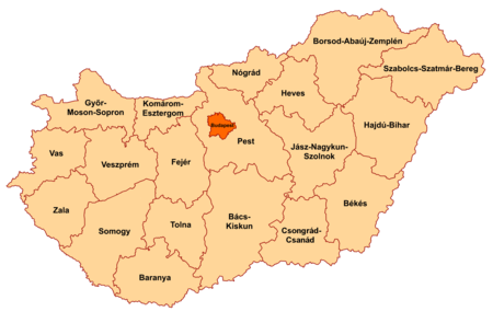
Hungary is subdivided administratively into 19 counties and the capital city Budapest.[1]
List of counties[change | change source]
| County | Coat of arms |
County seat | Area (km²) |
Population (2019) |
Population density (people/km², 2019) |
Map | No. of district |
No. of municipalities |
|---|---|---|---|---|---|---|---|---|
| Baranya | Pécs | 4429.60 | 360,704 | 81 | 
|
10 | 301 | |
| Bács-Kiskun | Kecskemét | 8444.89 | 503,825 | 60 | 
|
11 | 119 | |
| Békés | Békéscsaba | 5629.71 | 334,264 | 59 | 
|
9 | 75 | |
| Borsod-Abaúj-Zemplén | Miskolc | 7247.19 | 642,447 | 89 | 
|
– | ||
| Csongrád-Csanád | Szeged | 4262.79 | 399,012 | 94 | 
|
7 | 60 | |
| Fejér | Székesfehérvár | 4358.48 | 417,712 | 96 | 
|
8 | 108 | |
| Győr-Moson-Sopron | Győr | 4207.79 | 467,144 | 111 | 
|
7 | 183 | |
| Hajdú-Bihar | Debrecen | 6210.39 | 527,989 | 85 | 
|
10 | 82 | |
| Heves | Eger | 3637.17 | 294,609 | 81 | 
|
7 | 121 | |
| Jász-Nagykun-Szolnok | 
|
Szolnok | 5581.63 | 370,007 | 66 | 
|
9 | 78 |
| Komárom-Esztergom | Tatabánya | 2264.35 | 299,207 | 132 | 
|
6 | 76 | |
| Nógrád | 
|
Salgótarján | 2544.48 | 189,304 | 74 | 
|
6 | 131 |
| Pest | Budapest | 6391.18 | 1,278,874 | 200 | 
|
18 | 187 | |
| Somogy | Kaposvár | 6065.06 | 301,429 | 50 | 
|
8 | 245 | |
| Szabolcs-Szatmár-Bereg | Nyíregyháza | 5935.92 | 552,964 | 93 | 
|
13 | 229 | |
| Tolna | 
|
Szekszárd | 3703.20 | 217,463 | 59 | 
|
6 | 109 |
| Vas | Szombathely | 3336.11 | 253,551 | 76 | 
|
7 | 216 | |
| Veszprém | Veszprém | 4463.64 | 341,317 | 76 | 
|
10 | 217 | |
| Zala | Zalaegerszeg | 3783.84 | 268,648 | 71 | 
|
6 | 258 | |
| Hungary | Budapest | 93,023 | 9,772,756 | 105 | 
|
174 | 3176 | |
References[change | change source]
- ↑ Gazetteer of Hungary, 1 January 2019, Központi Statisztikai Hivatal, 2019, ISSN 1217-2952, retrieved 8 August 2021.