Croydon
| Croydon | |
|---|---|
|
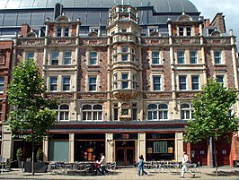
From top to bottom: the Old Town Hall and Clocktower (with the Spreadeagle in the foreground), Katharine Street; the Grants Building, High Street | |
| Location within Greater London | |
| Population | 384,837 (Addiscombe, Broad Green, Fairfield, Waddon, Croham, Selhurst, Ashburton, Woodside, Sanderstead, Shirley and Selsdon and Ballards wards)[1] |
| OS grid reference | TQ335655 |
| • Charing Cross | 9.4 mi (15.1 km) N |
| London borough | |
| Ceremonial county | Greater London |
| Region | |
| Country | England |
| Sovereign state | United Kingdom |
| Post town | CROYDON |
| Postcode district | CR0 |
| Dialling code | 020 |
| Police | Metropolitan |
| Fire | London |
| Ambulance | London |
| UK Parliament | |
| London Assembly | |
Croydon is a large town in Greater London, southern England in the United Kingdom. It is south of London and is part of the London Borough of Croydon.
History[change | change source]
The town grew up from Anglo-Saxon times around a palace belonging to the Archbishop of Canterbury. In 1276 the archbishop allowed a weekly market to take place nearby and this date is taken as the founding of the town. The town grew in the eighteenth century as a stage coach stop on the way to the popular seaside town of Brighton from London. In the nineteenth century railways put the town only 15 minutes from London by fast train and it grew 23 times in terms of the number of people living there between 1801 and 1901.
Things to do[change | change source]

Croydon is well known for having many places to go shopping, which includes two shopping centres called Centrale and the Whitgift Centre. A third one called Park Place is planned. Croydon has been rated the 20th best shopping area in the UK. It is also well known for holding a lot of offices for companies to let. The council wants to keep Croydon a big town by building more offices and entertainment facilities so a new place called the Croydon Gateway is planned. Purley Way, just west of Croydon, is a large retail park area which has many shops like Comet (which went in admin in 2012), Sainsbury's, McDonald's, IKEA, Argos, M&S, Boots along with a cinema and bowling alley.
Transport[change | change source]
Croydon is very easy to get to. There is a large bus station on the edge of Croydon, and three railway stations called East Croydon, West Croydon, and South Croydon.
Croydon is also served by Tramlink, a tram system, the only tram system in all of Greater London. It is the place where all four routes meet. They go to places like Elmers End and Beckenham in Bromley to the east, Wimbledon and Mitcham in Merton to the west, and Addington and Addiscombe to the south.
References[change | change source]
- ↑ "2011 Census Ward Population Estimates | London DataStore". Archived from the original on 22 February 2014. Retrieved 9 June 2014.


