
File:Hurricane Maria September 6 2005.jpg

Size of this preview: 600 × 600 pixels. Other resolutions: 240 × 240 pixels | 480 × 480 pixels | 768 × 768 pixels | 1,024 × 1,024 pixels | 2,048 × 2,048 pixels | 6,000 × 6,000 pixels.
Original file (6,000 × 6,000 pixels, file size: 4.99 MB, MIME type: image/jpeg)
| This is a file from the Wikimedia Commons. Information from its description page there is shown below. Commons is a freely licensed media file repository. You can help. |
Summary
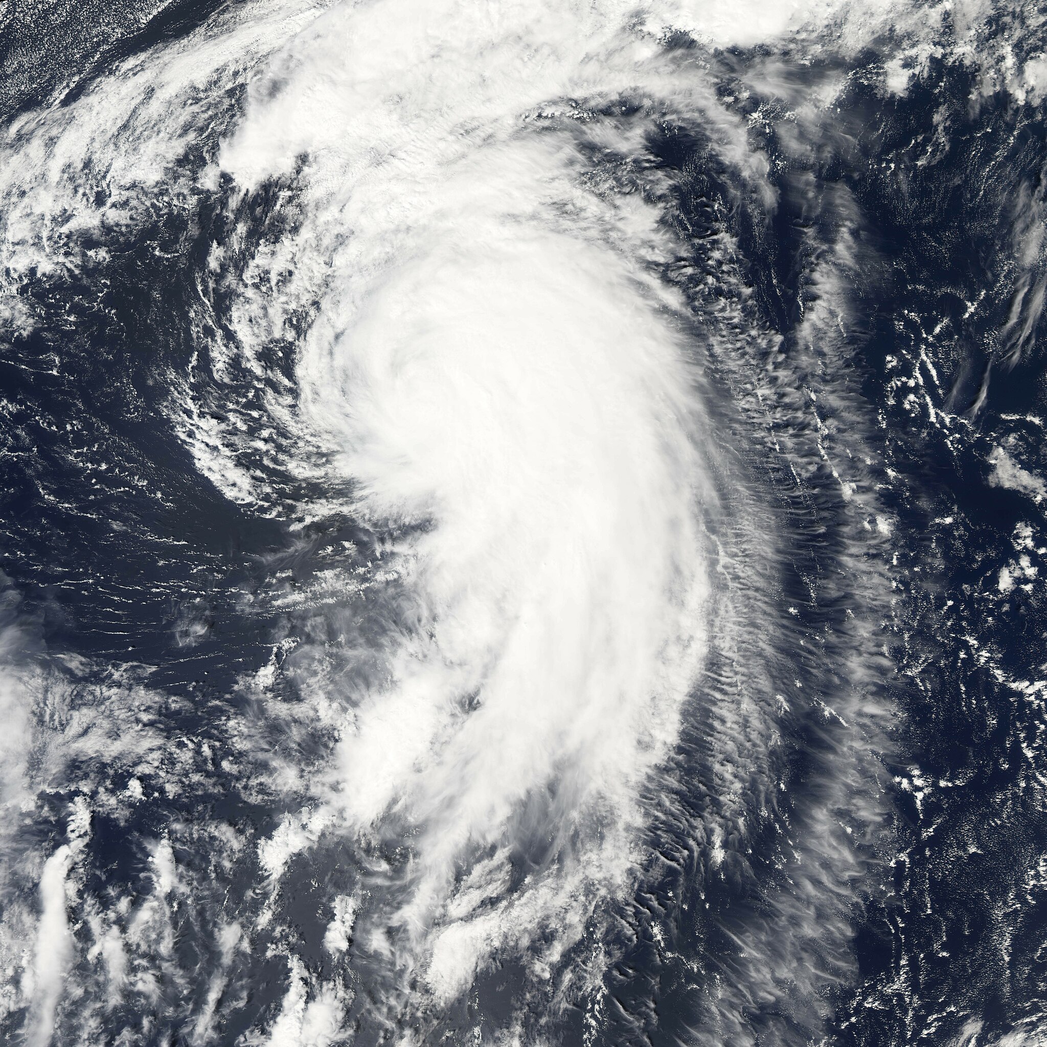
| Description | Hurricane Maria is spinning north over the Atlantic Ocean, well away from land. The storm reached its maximum intensity on September 6, 2005, several hours before the Moderate Resolution Imaging Spectroradiometer (MODIS) on NASA’s Aqua satellite captured this image at 1:45 ADT (16:45 UTC). At this time, the storm had winds of about 160 kilometers per hour (100 miles per hour) with gusts to 195 km/hr (120 mph), down from its previous intensity of 185 km/hr (115 mph) with gusts to 220 km/hr (140 mph). Maria is expected to continue to weaken as it moves north. It is not forecast to affect land. | |||||
| Date | ||||||
| Source | http://earthobservatory.nasa.gov/NaturalHazards/natural_hazards_v2.php3?img_id=13107 | |||||
| Author | NASA image created by Jesse Allen, Earth Observatory, using data provided courtesy of the MODIS Rapid Response team. | |||||
| Permission (Reusing this file) |
|

File history
Click on a date/time to view the file as it appeared at that time.
| Date/Time | Thumbnail | Dimensions | User | Comment | |
|---|---|---|---|---|---|
| current | 17:52, 29 July 2006 | | 6,000 × 6,000 (4.99 MB) | Good kitty | |
| 03:13, 8 January 2006 |  | 1,500 × 1,500 (802 KB) | Jdorje~commonswiki | ||
| 21:08, 7 September 2005 |  | 6,000 × 6,000 (3.2 MB) | Tom | {{PD-USGov-NASA}} Hurricane Maria spinning north over the Atlantic Ocean, well away from land. The storm reached its maximum intensity on September 6, 2005, several hours before the Moderate Resolution Imaging Spectroradiometer (MOD |
File usage
The following page uses this file:
Global file usage
The following other wikis use this file:
- Usage on de.wikipedia.org
- Usage on en.wikipedia.org
- Usage on eo.wikipedia.org
- Usage on es.wikipedia.org
- Usage on eu.wikipedia.org
- Usage on fr.wikipedia.org
- Usage on pt.wikipedia.org
- Usage on sv.wikinews.org
- Usage on www.wikidata.org
- Usage on zh.wikipedia.org