
Grächen
Grächen | |
|---|---|
 Coat of arms | |
Location of Grächen  | |
 Grächen  Grächen | |
| Coordinates: 46°10′N 7°49′E / 46.167°N 7.817°E | |
| Country | Switzerland |
| Canton | Valais |
| District | Visp |
| Government | |
| • Mayor | Jakob Walter |
| Area | |
| • Total | 14.0 km2 (5.4 sq mi) |
| Elevation | 1,619 m (5,312 ft) |
| Population (31 December 2018)[2] | |
| • Total | 1,251 |
| • Density | 89/km2 (230/sq mi) |
| Time zone | UTC+01:00 (Central European Time) |
| • Summer (DST) | UTC+02:00 (Central European Summer Time) |
| Postal code(s) | 3925 |
| SFOS number | 6285 |
| Surrounded by | Eisten, Embd, St. Niklaus, Stalden, Törbel |
| Website | www SFSO statistics |
Grächen is a municipality of the district of Visp in the canton of Valais in Switzerland.
It is at an elevation of 1,620 meters (5,310 ft) on a terrace above St. Niklaus in the Mattertal, north of the Mischabel range (and Dom).
Gallery[change | change source]
-
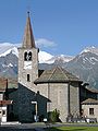 Church of Grächen
 -
 Grächen
 -
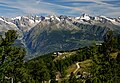 Hannigalp
 -
 Houses near Grächen


References[change | change source]
- ↑ 1.0 1.1 "Arealstatistik Standard - Gemeinden nach 4 Hauptbereichen". Federal Statistical Office. Retrieved 13 January 2019.
- ↑ "Ständige Wohnbevölkerung nach Staatsangehörigkeitskategorie Geschlecht und Gemeinde; Provisorische Jahresergebnisse; 2018". Federal Statistical Office. 9 April 2019. Retrieved 11 April 2019.
Other websites[change | change source]
![]() Media related to Grächen at Wikimedia Commons
Media related to Grächen at Wikimedia Commons
- Official website of the municipality of Grächen (in German)
- information.[permanent dead link] (in English)
- Grächen in German, French and Italian in the online Historical Dictionary of Switzerland.