
Henggart
Henggart | |
|---|---|
 Coat of arms | |
Location of Henggart  | |
 Henggart  Henggart | |
| Coordinates: 47°34′N 8°41′E / 47.567°N 8.683°E | |
| Country | Switzerland |
| Canton | Zurich |
| District | Andelfingen |
| Area | |
| • Total | 3.03 km2 (1.17 sq mi) |
| Elevation | 440 m (1,440 ft) |
| Population (31 December 2018)[2] | |
| • Total | 2,239 |
| • Density | 740/km2 (1,900/sq mi) |
| Time zone | UTC+01:00 (Central European Time) |
| • Summer (DST) | UTC+02:00 (Central European Summer Time) |
| Postal code(s) | 8444 |
| SFOS number | 0031 |
| Surrounded by | Dägerlen, Hettlingen, Humlikon, Neftenbach |
| Website | www SFSO statistics |
Henggart is a municipality in the district of Andelfingen in the canton of Zurich in Switzerland.
Gallery[change | change source]
-
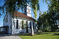 Church of Henggart
 -
 Henggart train station
 -
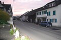 Village center of Henggart
 -
 Bridge over the Highway A4
 -
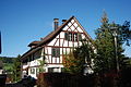 Timber framing house at Henggart
 -
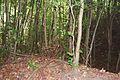 Earthbank on Schlossbuch at Henggart
_017.JPG)


_061.JPG)
_018.JPG)
_038.JPG)
References[change | change source]
- ↑ 1.0 1.1 "Arealstatistik Standard - Gemeinden nach 4 Hauptbereichen". Federal Statistical Office. Retrieved 13 January 2019.
- ↑ "Ständige Wohnbevölkerung nach Staatsangehörigkeitskategorie Geschlecht und Gemeinde; Provisorische Jahresergebnisse; 2018". Federal Statistical Office. 9 April 2019. Retrieved 11 April 2019.
Other websites[change | change source]
![]() Media related to Henggart at Wikimedia Commons
Media related to Henggart at Wikimedia Commons
- Official Website (in German)
- Henggart in German, French and Italian in the online Historical Dictionary of Switzerland.