Hoevelaken
Hoevelaken | |
|---|---|
Town | |
 | |
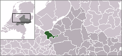
 The town centre (dark green) and the statistical district (light green) of Hoevelaken in the municipality of Nijkerk. | |
| Coordinates: 52°10′N 5°28′E / 52.167°N 5.467°E | |
| Country | Netherlands |
| Province | Gelderland |
| Municipality | Nijkerk |
| Population | |
| • Total | 9,040 |
| [1] | |
| Time zone | UTC+1 (CET) |
| • Summer (DST) | UTC+2 (CEST) |
Hoevelaken is a town in the Dutch province of Gelderland. It is a part of the city of Nijkerk, and lies about 5 km east of Amersfoort.
References[change | change source]
- ↑ Statistics Netherlands (CBS), Statline: Kerncijfers wijken en buurten 2003-2005. As of 1 January 2005.


