
Lake Chungará
| Lake Chungará | |
|---|---|
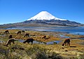
 Lake and Parinacota Volcano | |
| Location | Arica y Parinacota Region, Chile |
| Coordinates | 18°15′S 69°09′W / 18.250°S 69.150°W |
| Type | Natural |
| Primary inflows | Chungará, Sopocalane |
| Basin countries | Chile |
| Surface area | 21.5 km2 (8.3 sq mi) |
| Average depth | 33 m (108 ft) |
| Surface elevation | 4,517 m (14,820 ft) |
| Islands | none |
| Settlements | none |
Lake Chungará (from Aymara: chunkara "moss on the stone") is a lake in the extreme north of Chile, in the Altiplano of the Arica y Parinacota region. It is the 29th highest lake in the world (and the 10th highest in South America).[1]
The lake is near the volcanos Parinacota (6,342 m [20,807 ft]) and Pomerape (6,222 m [20,413 ft]). It is part of the Lauca National Park, in the Putre comuna. The lake is at about 54 km (34 mi) to the east of the town of Putre and about 9 km (5.6 mi) to the west of the border with Bolivia.
In the lake and streams nearby, there are some small fish that are endemic to the lake basin: pencil catfish, Trichomycterus chungaraensis,[2] and Orestias chungarensis.[3]
-
-
 Parinacota Volcano and Lake Chungará
 -
 Morning on Chungará Lake.


Related pages[change | change source]
References[change | change source]
- ↑ Carl Drews. "The Highest Lake in the World". The Highest Lake. Archived from the original on 24 August 2007. Retrieved 6 July 2016.
- ↑ "Trichomycterus chungaraensis Arratia, 1983". FishBase. Retrieved 6 July 2016.
- ↑ "Orestias chungarensis Vila & Pinto, 1987". FishBase. Retrieved 6 July 2016.
Other websites[change | change source]
![]() Media related to Lake Chungará at Wikimedia Commons
Media related to Lake Chungará at Wikimedia Commons