Marion County, Mississippi
Marion County | |
|---|---|
 Marion County courthouse in Columbia | |
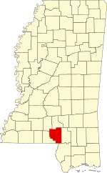
 Location within the U.S. state of Mississippi | |
 Mississippi's location within the U.S. | |
| Coordinates: 31°14′N 89°49′W / 31.23°N 89.82°W | |
| Country | |
| State | |
| Founded | 1811 |
| Named for | Francis Marion |
| Seat | Columbia |
| Largest city | Columbia |
| Area | |
| • Total | 549 sq mi (1,420 km2) |
| • Land | 542 sq mi (1,400 km2) |
| • Water | 6.2 sq mi (16 km2) 1.1% |
| Population (2020) | |
| • Total | 24,441 |
| • Density | 45/sq mi (17/km2) |
| Time zone | UTC−6 (Central) |
| • Summer (DST) | UTC−5 (CDT) |
| Congressional district | 4th |
| Website | www |
Marion County is a county in the U.S. state of Mississippi. As of the 2020 census, 24,441 people lived there.[1] Its county seat is Columbia.[2] The county is named for American Revolutionary War guerrilla leader Francis Marion also known as The Swamp Fox.[3]
References[change | change source]
- ↑ "QuickFacts: Marion County, Mississippi". United States Census Bureau. Retrieved January 4, 2024.
- ↑ "Find a County". National Association of Counties. Retrieved 2011-06-07.
- ↑ Gannett, Henry (1905). The Origin of Certain Place Names in the United States. U.S. Government Printing Office. p. 200.
Other websites[change | change source]
Wikimedia Commons has media related to Marion County, Mississippi.


