
Monte Mario
| Mario Mountain | |
|---|---|
 | |
| Highest point | |
| Elevation | 139 m (456 ft) |
| Coordinates | 41°55′27.41″N 12°27′07.38″E / 41.9242806°N 12.4520500°E |
| Geography | |
| Location | |
Mario Mountain (Italian: Monte Mario) is a hill in the northwest part of Rome, on the right side of the Tiber River. It is 139 metres tall, one of the tallest hill in town. Rome and Vatican City are visible from the hill.
History[change | change source]
Excavations near Monte Mario have found a flint tool and animal teeth. The remains date back to about 65,000 years ago.
The hill was known as Mons Vaticanus or Clivus Cinnae (from the name of the Roman Consul Lucius Cornelius Cinna) during Ancient Rome.
In the Middle Ages, Monte Mario was located on the Via Francigena, a pilgrimage route from Canterbury to Rome. Pilgrims called it Mons Gaudii (Latin for Mount of the Joy).[1]
Description[change | change source]
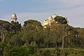
Mario Mountain is a nature reserve and it is home to an observatory.
Gallery[change | change source]
-
 Astronomical observatory
 -
 Astronomical observatory
 -
 View of Mario Mountain


References[change | change source]
- ↑ According to Ferdinand Gregorovius, Geschichte der Stadt Rom im Mittelalter, vol. IV, Munich, C. H. Beck, 1988, p. 660.