
Neshoba County, Mississippi
Neshoba County | |
|---|---|
 Neshoba County courthouse and Confederate Monument in Philadelphia | |
 Location within the U.S. state of Mississippi | |
 Mississippi's location within the U.S. | |
| Coordinates: 32°45′N 89°07′W / 32.75°N 89.12°W | |
| Country | |
| State | |
| Founded | 1833 |
| Named for | Choctaw for “wolf” |
| Seat | Philadelphia |
| Largest city | Philadelphia |
| Area | |
| • Total | 572 sq mi (1,480 km2) |
| • Land | 570 sq mi (1,500 km2) |
| • Water | 1.5 sq mi (4 km2) 0.3% |
| Population (2020) | |
| • Total | 29,087 |
| • Density | 51/sq mi (20/km2) |
| Time zone | UTC−6 (Central) |
| • Summer (DST) | UTC−5 (CDT) |
| Congressional district | 3rd |
| Website | www |
Neshoba County is a county found in the U.S. state of Mississippi. As of the 2020 census, 29,087 people lived there.[1] Its county seat is Philadelphia.[2]
References[change | change source]
- ↑ "QuickFacts: Neshoba County, Mississippi". United States Census Bureau. Retrieved January 4, 2024.
- ↑ "Find a County". National Association of Counties. Retrieved 2011-06-07.
Municipalities and communities of Neshoba County, Mississippi, United States | ||
|---|---|---|
| City | 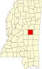 | |
| Town | ||
| CDPs | ||
| Other communities | ||
| Indian reservation | ||
| Footnotes | ‡This populated place also has portions in an adjacent county or counties | |