Phocis
Phocis
Περιφερειακή ενότητα Φωκίδας | |
|---|---|
 Municipalities of Phocis | |
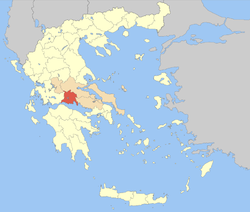
 Phocis within Greece | |
| Coordinates: 38°30′N 22°15′E / 38.500°N 22.250°E | |
| Country | Greece |
| Region | Central Greece |
| Capital | Amfissa |
| Area | |
| • Total | 2,120 km2 (820 sq mi) |
| Population (2011) | |
| • Total | 40,343 |
| • Density | 19/km2 (49/sq mi) |
| Time zone | UTC+2 (EET) |
| • Summer (DST) | UTC+3 (EEST) |
| Postal codes | 33x xx |
| Area codes | 226x0, 26340 |
| ISO 3166 code | GR-07 |
| Car plates | ΑΜ |
| Website | www |
Phocis is one of the regional units of Greece. It is part of the administrative region of Central Greece. It is near the western mountainsides of Parnassus.[1]
References[change | change source]
