Red Willow County, Nebraska
Red Willow County | |
|---|---|
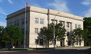
 Red Willow County Courthouse in McCook | |
 Location within the U.S. state of Nebraska | |
 Nebraska's location within the U.S. | |
| Coordinates: 40°11′N 100°29′W / 40.18°N 100.48°W | |
| Country | |
| State | |
| Founded | 1873 |
| Named for | Red Willow Creek |
| Seat | McCook |
| Largest city | McCook |
| Area | |
| • Total | 718 sq mi (1,860 km2) |
| • Land | 717 sq mi (1,860 km2) |
| • Water | 1.0 sq mi (3 km2) 0.1% |
| Population (2020) | |
| • Total | 10,702 |
| • Density | 15.0/sq mi (5.8/km2) |
| Time zone | UTC−6 (Central) |
| • Summer (DST) | UTC−5 (CDT) |
| Congressional district | 3rd |
| Website | www |
Red Willow County is a county in the U.S. state of Nebraska. As of the 2020 census, 10,702 people lived there.[1] The county seat is McCook.[2] It was founded in 1873.
Geography[change | change source]
The county has a total area of 718 square miles (1,860 km2).
Bordering counties[change | change source]
- Furnas County, Nebraska (east)
- Decatur County, Kansas (south)
- Rawlins County, Kansas (southwest)
- Hitchcock County, Nebraska (west)
- Frontier County, Nebraska (north)
Communities[change | change source]
References[change | change source]
- ↑ "QuickFacts: Red Willow County, Nebraska". United States Census Bureau. Retrieved January 10, 2024.
- ↑ "Find a County". National Association of Counties. Retrieved 2011-06-07.
Other websites[change | change source]
Wikimedia Commons has media related to Red Willow County, Nebraska.

