Sittingbourne
| Sittingbourne | |
|---|---|
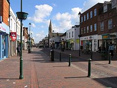
 Sittingbourne High Street | |
| Location within Kent | |
| Population | 62,500 |
| OS grid reference | TQ905635 |
| District | |
| Shire county | |
| Region | |
| Country | England |
| Sovereign state | United Kingdom |
| Post town | SITTINGBOURNE |
| Postcode district | ME9, ME10 |
| Dialling code | 01795 |
| Police | Kent |
| Fire | Kent |
| Ambulance | South East Coast |
| UK Parliament | |
Sittingbourne is an industrial town in Swale, Kent, England. It is located east of Gillingham. About 62,500 people live in Sittingbourne. [1] Its postcodes are ME9 and ME10.
Twin towns[change | change source]
References[change | change source]
- ↑ "Population and Census Information". Swale Borough Council. Archived from the original on 14 October 2014. Retrieved 13 November 2013.
Other websites[change | change source]
 Media related to Sittingbourne at Wikimedia Commons
 Sittingbourne travel guide from Wikivoyage

