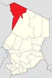
Tibesti Region
Appearance
21°21′16″N 17°00′04″E / 21.35444°N 17.00111°E
Tibesti
تيبستي | |
|---|---|
 Map of Chad showing Tibesti | |
| Country | Chad |
| Departments | 2 |
| Sub-prefectures | 7 |
| Region | 2008 |
| Capital | Bardaï |
| Population (2009)[1] | |
| • Total | 25,483 |
| The 2009 census figure is an official estimate.[1] | |
Tibesti Region is a region in Chad. Its capital is Bardaï.
It was created in 2008 when the former Borkou-Ennedi-Tibesti Region was split into three. The Tibesti Department became the Tibesti Region. The region is named for the Tibesti Mountains, one of the most prominent mountain chains in the Sahara Desert.
The area fell under French rule during the Scramble for Africa in the late 19th century. Prior to 1931 much of the region belonged to what is now Niger, as part of the French West Africa colony.[2]
Subdivisions
[change | change source]The region of Tibesti is divided into two departments:
| Department | Capital | Sub-prefectures |
|---|---|---|
| Tibesti Est | Bardaï | Bardaï, Zoumri, Aouzou, Yebbibou |
| Tibesti Ouest | Zouar | Zouar, Wour, Goubonne |
References
[change | change source]- ↑ 1.0 1.1 DEUXIEME RECENSEMENT GENERAL DE LA POPULATION ET DE L'HABITAT: RESULTATS GLOBAUX DEFINITIFS (PDF) (Report). INSEED. March 2012. p. 24. Archived from the original (PDF) on 14 September 2014. Retrieved 10 March 2017.
- ↑ International Boundary Study No. 73 – Chad-Niger Boundary (PDF), 1 August 1966, archived from the original (PDF) on 4 August 2020, retrieved 5 October 2019
