Valhalla, New York
Valhalla, New York | |
|---|---|
 Kensico Dam at the Kensico Reservoir in Valhalla | |
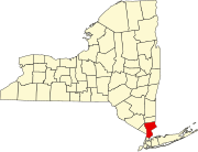
 Location of Valhalla, New York | |
| Coordinates: 41°4′30″N 73°46′31″W / 41.07500°N 73.77528°W | |
| Country | United States |
| State | New York |
| County | Westchester |
| Town | Mount Pleasant |
| Area | |
| • Total | 0.83 sq mi (2.15 km2) |
| • Land | 0.83 sq mi (2.15 km2) |
| • Water | 0.00 sq mi (0.00 km2) |
| Elevation | 256 ft (78 m) |
| Population | |
| • Total | 3,213 |
| • Density | 3,871.1/sq mi (1,495.4/km2) |
| Time zone | UTC-5 (Eastern (EST)) |
| • Summer (DST) | UTC-4 (EDT) |
| ZIP code | 10595 |
| Area code | 914 |
| FIPS code | 36-76639 |
| GNIS feature ID | 0968353 |
Valhalla is a hamlet and census-designated place (CDP) located within the town of Mount Pleasant, in Westchester County, New York, United States, in the New York City metropolitan area. Its population was 3,213 at the 2020 U.S. Census.[2]
References[change | change source]
- ↑ "ArcGIS REST Services Directory". United States Census Bureau. Retrieved September 20, 2022.
- ↑ 2.0 2.1 "Profile of General Population and Housing Characteristics: 2020 Demographic Profile Data (DP-1): Valhalla CDP, New York". United States Census Bureau. Retrieved March 11, 2024.

