Kostanay Region
Kostanay Region
| |
|---|---|
 | |
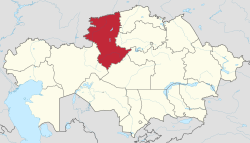
 Map of Kazakhstan, location of Kostanay Province highlighted | |
| Coordinates: 53°12′N 63°38′E / 53.200°N 63.633°E | |
| Country | |
| Established | 1936 |
| Capital | Kostanay |
| Government | |
| • Akim | Kumar Aksakalov[1] |
| Area | |
| • Total | 196,001 km2 (75,676 sq mi) |
| Population (2023)[2] | |
| • Total | 832,110 |
| • Density | 4.2/km2 (11/sq mi) |
| Time zone | UTC+6 (East) |
| • Summer (DST) | UTC+6 (not observed) |
| Postal codes | 110000 |
| Area codes | +7 (714) |
| ISO 3166 code | KZ-KUS |
| Vehicle registration | 10, P |
| Districts | 16 |
| Cities | 5 |
| Townships | 8 |
| Villages | 255 |
| Website | www |
Kostanay Region or Kostanay Province (Kazakh: Қостанай облысы; Russian: Костанайская область) is one of the regions in the north of Kazakhstan. The capital of the region is the city of Kostanay. As of 2023, the population is 832,110 people.[3]
The region borders on the Aktobe, Ulytau, Karaganda, Akmola and North Kazakhstan Regions of Kazakhstan. It also borders the Orenburg, Chelyabinsk and Kurgan Oblasts of Russia.
There are six cities in the region: Kostanay, Arkalyk, Rudny, Lisakovsk, Zhitikara and Tobyl.
References[change | change source]
- ↑ "Кумар Аксакалов стал акимом Костанайской области". tengrinews.kz (in Russian). 2022-12-01.
- ↑ Agency of statistics of the Republic of Kazakhstan: Численность населения Республики Казахстан по областям с начала 2013 года до 1 февраля 2013 года (russisch; Excel-Datei; 55 kB).
- ↑ "Population of the Republic of Kazakhstan by gender and type of area (as of 2023-01-01)". QazStat. 2023-01-01. Archived from the original on 2023-03-05.

