2009 L'Aquila earthquake
Appearance
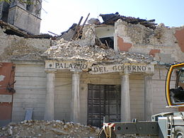
 A government's office damaged by the 2009 earthquake in L'Aquila, Abruzzo, Italy | |
| UTC time | 2009-04-06 01:32:42 |
|---|---|
| ISC event | 13438018 |
| USGS-ANSS | ComCat |
| Local date | 6 April 2009 |
| Local time | 03:32 CEST |
| Magnitude | Mw6.3 (GCMT) |
| Depth | 9.46 km (5.88 mi) |
| Epicenter | 42°20′51″N 13°22′48″E / 42.3476°N 13.3800°E |
| Areas affected | Abruzzo, Italy |
| Total damage | $16 billion |
| Max. intensity | X (Extreme)[1] |
| Peak acceleration | 0.66 g |
| Peak velocity | 42.83 cm/s[2] |
| Casualties | 308 dead 1,500+ injured 65,000+ homeless |
The 2009 L'Aquila earthquake occurred on 6 April 2009 in L'Aquila, Abruzzo, Central Italy.[3] It occurred as a result of faulting in the central Apennines. This earthquake killed over 300 people. It was Italy's most destructive of the last 30 years (as of 2009).
References
[change | change source]- ↑ Gabriele Ameri; Dino Bindi; Francesca Pacor; Fabrizio Galadini (2011). "The 2009 April 6, Mw 6.3, L'Aquila (central Italy) earthquake: finite-fault effects on intensity data". Geophysical Journal International. 186 (2): 837–851. Bibcode:2011GeoJI.186..837A. doi:10.1111/j.1365-246X.2011.05069.x.
{{cite journal}}: CS1 maint: unflagged free DOI (link) - ↑ "Table 3 Peak ground acceleration (PGA), Velocity (PGV) and Displacement".
- ↑ USGS. "M6.3 – central Italy". United States Geological Survey.


