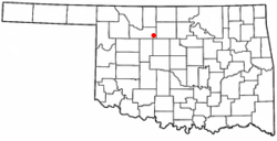
Ames, Oklahoma
Ames, Oklahoma | |
|---|---|
 Location of Ames, Oklahoma | |
| Coordinates: 36°14′49″N 98°11′10″W / 36.24694°N 98.18611°W | |
| Country | United States |
| State | Oklahoma |
| County | Major |
| Area | |
| • Total | 0.28 sq mi (0.72 km2) |
| • Land | 0.28 sq mi (0.72 km2) |
| • Water | 0.00 sq mi (0.00 km2) |
| Elevation | 1,211 ft (369 m) |
| Population (2020) | |
| • Total | 193 |
| • Density | 694.24/sq mi (267.72/km2) |
| Time zone | UTC-6 (Central (CST)) |
| • Summer (DST) | UTC-5 (CDT) |
| ZIP code | 73718 |
| Area code | 580 |
| FIPS code | 40-01950[3] |
| GNIS feature ID | 2412361[2] |
Ames is a town in the U.S. state of Oklahoma.
References[change | change source]
- ↑ "ArcGIS REST Services Directory". United States Census Bureau. Retrieved September 20, 2022.
- ↑ 2.0 2.1 U.S. Geological Survey Geographic Names Information System: Ames, Oklahoma
- ↑ "U.S. Census website". United States Census Bureau. Retrieved 2008-01-31.
