
Anderson County, Kentucky
Anderson County | |
|---|---|
 Anderson County courthouse in Lawrenceburg | |
 Location within the U.S. state of Kentucky | |
 Kentucky's location within the U.S. | |
| Coordinates: 38°00′N 84°59′W / 38°N 84.99°W | |
| Country | |
| State | |
| Founded | 1827 |
| Named for | Richard Clough Anderson Jr. |
| Seat | Lawrenceburg |
| Largest city | Lawrenceburg |
| Area | |
| • Total | 204 sq mi (530 km2) |
| • Land | 202 sq mi (520 km2) |
| • Water | 2.4 sq mi (6 km2) 1.2% |
| Population (2020) | |
| • Total | 23,852 |
| • Density | 120/sq mi (45/km2) |
| Time zone | UTC−5 (Eastern) |
| • Summer (DST) | UTC−4 (EDT) |
| Congressional districts | 1st, 6th |
| Website | andersoncounty |
Anderson County is a county in the U.S. state of Kentucky. As of the 2020 census, the population was 23,852.[1] Its county seat is Lawrenceburg.[2]
References[change | change source]
- ↑ "QuickFacts: Anderson County, Kentucky". United States Census Bureau. Retrieved October 4, 2023.
- ↑ "Find a County". National Association of Counties. Archived from the original on 2011-05-31. Retrieved 2011-06-07.
Municipalities and communities of Anderson County, Kentucky, United States | ||
|---|---|---|
| City | 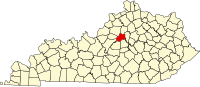 | |
| Unincorporated communities | ||
| Ghost town | ||
| International | |
|---|---|
| National | |
| Other | |