
Arros (river)
| Arros | |
|---|---|
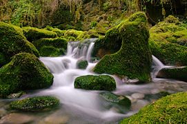
 The Arros in Saint-Sever-de-Rustan | |
  | |
| Location | |
| Country | France |
| Physical characteristics | |
| Source | |
| - location | Baronnies of Pyrenees |
| Mouth | |
| - location | Adour |
| - coordinates | 43°39′44″N 0°1′41″W / 43.66222°N 0.02806°W |
| Length | 130 km (81 mi) |
| Basin size | 947 km2 (366 sq mi) |
| Discharge | |
| - average | 9 m3/s (320 cu ft/s) |
| Basin features | |
| Progression | Adour→ Atlantic Ocean |
The Arros is a river in southwestern France that flows through the Hautes-Pyrénées and Gers departments, in the Occitanie region. The Arros is a right tributary of the Adour river.
The valleys of the Arros and of the Adour rivers were part of the Comté de Bigorre ("County of Bigorre"). The valley of the Arros was called the Rivière-Haute ("Upper River") and the valley of the Adour was called the Rivière-Basse ("Lower River").
Geography[change | change source]
The Arros river has a length of 130.2 km (80.9 mi),[1] and a drainage basin with an area of approximately 1,283 km2 (495 sq mi).
Its average yearly discharge (volume of water which passes through a section of the river per unit of time) is 6.92 m3/s (244 cu ft/s) at Juillac in the Gers department.[2]
 |
Course[change | change source]
The Arros river starts, an altitude of 586 m (1,922.6 ft), in the Forêt des Baronnies, southeast of Bagnères-de-Bigorre, in the Esparros commune.[3] It then flows from south to north through the Hautes-Pyrénées department. It passes through the towns of Bourg-de-Bigorre, Tournay and Chelle-Debat. It gets in the Gers department and passes through the towns of Montégut-Arros and Villecomtal-sur-Arros.
About 4 km (2.5 mi) from Plaisance, the Arros joins, by its right side, the Adour river at an altitude of 113 m (370.7 ft).[4]
The Arros flows through 55 communes and two of them, both in the Gers department, have the name of the river: Montégut-Arros and Villecomtal-sur-Arros.
Main tributaries[change | change source]
Most of the tributaries of the Arros are small streams; the only important tributaries are:
|
Left tributary:
|
|
Right tributary:
|
Gallery[change | change source]
-
 Near the source of the Arros.
 -
 The upper Arros in a very humid valley.
 -
 The Arros in Villecomtal-sur-Arros.
 -
 The Arros in Plaisance.


Related pages[change | change source]
References[change | change source]
- ↑ "L'Arros (Q0--0250)" (in French). SANDRE - Portail national d'accès aux référentiels sur l'eau. Retrieved 9 June 2017.
- ↑ 2.0 2.1 "L'Arros à Juillac" (in French). Banque Hydro. Archived from the original on 1 October 2018. Retrieved 9 June 2017.
- ↑ "Source de l'Arros" (in French). Géoportail. Retrieved 9 June 2017.
- ↑ "Confluence de l'Arros" (in French). Géoportail. Retrieved 9 June 2017.