Barneveld
Appearance
Barneveld | |
|---|---|
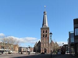
 Church in Barneveld | |
 Location in Gelderland | |
| Coordinates: 52°8′N 5°35′E / 52.133°N 5.583°E | |
| Country | Netherlands |
| Province | Gelderland |
| Government | |
| • Body | Municipal council |
| • Mayor | Asje van Dijk (CDA) |
| Elevation | 10 m (30 ft) |
| Population (January 2019)[3] | |
| • Total | 57,971 |
| • Density | 330/km2 (900/sq mi) |
| Demonym | Barnevelder |
| Time zone | UTC+1 (CET) |
| • Summer (DST) | UTC+2 (CEST) |
| Postcode | 3770–3785, 3794, 3886 |
| Area code | 0342, 0577 |
| Website | www |

Barneveld (![]() pronunciation (help·info)) is a municipality in the middle of the Netherlands, in the province Gelderland. The main centre is the village of Barneveld.
pronunciation (help·info)) is a municipality in the middle of the Netherlands, in the province Gelderland. The main centre is the village of Barneveld.
The municipality has an area of 176.74 km².
Towns and villages of the municipality
[change | change source]
| Name | No. people within centre | No. people outside centre |
|---|---|---|
| Barneveld | 23,960 | 28,640 |
| Voorthuizen | 8,110 | 9,710 |
| Kootwijkerbroek | 1,810 | 4,870 |
| Garderen | 1,470 | 2,060 |
| Zwartebroek | 800 | 1,260 |
| Terschuur | 750 | 1,480 |
| Stroe | 720 | 1,500 |
| De Glind | 350 | 630 |
| Kootwijk | 130 | 280 |
| Bron: CBS [5] | ||
Other centres are: Essen, Esveld, Garderbroek, Harselaar, Kallenbroek, Moorst (partly), Wessel and Recreatiegebied Zeumeren.
Geography
[change | change source]The municipality neighbours Nijkerk, Putten and Ermelo to the north. Apeldoorn lies to the east. Municipalities Ede, Renswoude, Scherpenzeel and Woudenberg are to the south. Municipalities Leusden and Amersfoort neighbour Barneveld to the west.
Notable people born in Barneveld
[change | change source]- Jacobus Cornelius Kapteyn (1851–1922), astronomer
- Eduard Daniel van Oort (1876–1933), ornithologist
- Egbert Adriaan Kreiken (1896–1964), teacher and astronomer
- Conny van Bentum (born 1965), freestyle swimmer
- Alfred Schreuder (born 1972), footballer
References
[change | change source]Wikimedia Commons has media related to Barneveld.
- ↑ "College van B&W" [Board of mayor and aldermen] (in Dutch). Gemeente Barneveld. Retrieved 19 June 2014.
- ↑ "Postcodetool for 3771ER". Actueel Hoogtebestand Nederland (in Dutch). Het Waterschapshuis. Archived from the original on 25 December 2018. Retrieved 19 June 2014.
- ↑ "Bevolkingsontwikkeling; regio per maand" [Population growth; regions per month]. CBS Statline (in Dutch). CBS. 1 January 2019. Retrieved 1 January 2019.
- ↑ "Kerncijfers wijken en buurten 2020" [Key figures for neighbourhoods 2020]. StatLine (in Dutch). CBS. 24 July 2020. Retrieved 19 September 2020.
- ↑ CBS Statline, 1 januari 2006


