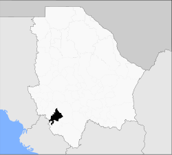
Batopilas Municipality
Appearance
Batopilas | |
|---|---|
Municipality | |
 Municipality of Batopilas in Chihuahua | |
| Coordinates: 27°2′N 107°44′W / 27.033°N 107.733°W | |
| Country | |
| State | Chihuahua |
| Municipal seat | Batopilas |
| Area | |
| • Total | 2,064.6 km2 (797.1 sq mi) |
| Population (2010) | |
| • Total | 14,362 |
Batopilas is one of the 67 municipalities of Chihuahua, in northern Mexico. The municipal seat is Batopilas. The municipality covers an area of 2,064.6 km².
In 2010, the municipality had a total population of 14,362.[1]
References
[change | change source]- ↑ "Batopilas". Catálogo de Localidades. Secretaría de Desarrollo Social (SEDESOL). Archived from the original on 11 April 2015. Retrieved 23 April 2014.

