Battambang province
Appearance
Battambang Province
បាត់ដំបង Phra Tabong | |
|---|---|
 | |
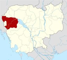
 Map of Cambodia highlighting Battambang Province | |
| Country | |
| Provincial status | 6 December 1907 |
| Capital | Battambang Municipality |
| Area | |
| • Total | 11,702 km2 (4,518 sq mi) |
| Population (2019) | |
| • Total | |
| • Density | 84/km2 (220/sq mi) |
| Time zone | UTC+7 (ICT) |
| ISO 3166 code | KH-2 |
| Website | battambang |
Battambang (Khmer: បាត់ដំបង, Bătdâmbâng [ɓatɗɑmɓɑːŋ], lit. 'The Lost Stick') is a province (khaet) of Cambodia. Its capital and largest city is Battambang.
The Tonlé Sap Biosphere Reserve is in the province. The temples Wat Ek Phnom and Wat Banan are also here. Seventy five percent of the area is jungles and mountains. The area has a tropical climate.
Battambang is divided into 13 districts and one municipality:
