Beit She'an
Appearance
Beit She'an
בֵּית שְׁאָן | |
|---|---|
| Hebrew transcription(s) | |
| • ISO 259 | Beit Šˀan |
| • Translit. | Bet Šəʼan |
| • Also spelled | Bet She'an (official) Beth Shean (unofficial) |
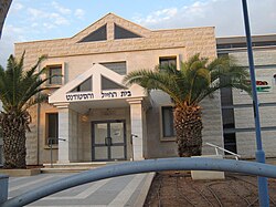
 Beit She'an Beit HaHayal VeHaStudent | |
| Coordinates: 32°30′N 35°30′E / 32.500°N 35.500°E | |
| Country | |
| District | Northern |
| Founded | 6th-5th millennia BCE (Earliest settlement) Bronze Age (Canaanite city) |
| Government | |
| • Mayor | Jackie Levy |
| Area | |
| • Total | 7,330 dunams (7.33 km2 or 2.83 sq mi) |
| Population (2022)[1] | |
| • Total | 19,073 |
| • Density | 2,600/km2 (6,700/sq mi) |
| Name meaning | House of Tranquillity[2] |
| Website | http://www.bet-shean.org.il |
Beit She'an (Hebrew: בֵּית שְׁאָן ![]() Bēṯ Šəʾān (help·info)), also known as Beisan (Arabic: بيسان
Bēṯ Šəʾān (help·info)), also known as Beisan (Arabic: بيسان ![]() Bisān (help·info)), and historically known as Scythopolis (Σκυθόπολις in Ancient Greek) is a city in the Northern District of Israel. It is known for its location near the Jordan River Valley and the Jezreel Valley.
Bisān (help·info)), and historically known as Scythopolis (Σκυθόπολις in Ancient Greek) is a city in the Northern District of Israel. It is known for its location near the Jordan River Valley and the Jezreel Valley.
References
[change | change source]- ↑ "Regional Statistics". Israel Central Bureau of Statistics. Retrieved 21 March 2024.
- ↑ Shahin, Mariam (2005). Palestine: A Guide. Interlink Books. pp. 159–165. ISBN 1-56656-557-X.


