Clarion County, Pennsylvania
Clarion County | |
|---|---|
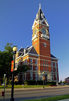
 Clarion County Courthouse | |
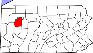
 Location within the U.S. state of Pennsylvania | |
 Pennsylvania's location within the U.S. | |
| Coordinates: 41°11′N 79°25′W / 41.19°N 79.42°W | |
| Country | |
| State | |
| Founded | March 11, 1839 |
| Named for | Clarion River |
| Seat | Clarion |
| Largest borough | Clarion |
| Area | |
| • Total | 610 sq mi (1,600 km2) |
| • Land | 601 sq mi (1,560 km2) |
| • Water | 9.0 sq mi (23 km2) 1.5% |
| Population (2020) | |
| • Total | 37,241 |
| • Density | 66/sq mi (25/km2) |
| Time zone | UTC−5 (Eastern) |
| • Summer (DST) | UTC−4 (EDT) |
| Congressional district | 15th |
| Website | www |
| Designated | April 26, 1982[1] |
Clarion County is a county in the U.S. state of Pennsylvania. As of the 2020 census, the population was 37,241.[2] Its county seat is Clarion.[3]
References[change | change source]
- ↑ "PHMC Historical Markers Search". Pennsylvania Historical and Museum Commission. Commonwealth of Pennsylvania. Archived from the original (Searchable database) on March 21, 2016. Retrieved 2014-01-25.
- ↑ "QuickFacts: Clarion County, Pennsylvania". United States Census Bureau. Retrieved January 20, 2024.
- ↑ National Association of Counties. "NACo County Explorer". Retrieved January 20, 2024.

