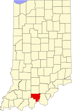
Crawford County, Indiana
Crawford County | |
|---|---|
 Crawford County Courthouse in English | |
 Location within the U.S. state of Indiana | |
 Indiana's location within the U.S. | |
| Coordinates: 38°17′N 86°28′W / 38.29°N 86.46°W | |
| Country | |
| State | |
| Founded | 1818 |
| Named for | William H. Crawford |
| Seat | English |
| Largest town | Marengo |
| Area | |
| • Total | 308.72 sq mi (799.6 km2) |
| • Land | 305.64 sq mi (791.6 km2) |
| • Water | 3.08 sq mi (8.0 km2) 1.00% |
| Population | |
| • Total | 10,526 |
| • Density | 34/sq mi (13/km2) |
| Time zone | UTC−5 (Eastern) |
| • Summer (DST) | UTC−4 (EDT) |
| Congressional districts | 8th, 9th |
| Website | www |
| Indiana county number 13 | |
Crawford County is a county in the U.S. state of Indiana. As of 2020, 10,526 people lived there.[1] The county seat is English.[2]
References[change | change source]
- ↑ 1.0 1.1 "QuickFacts: Crawford County, Indiana". United States Census Bureau. Retrieved September 25, 2023.
- ↑ "Find a County". National Association of Counties. Archived from the original on 2011-05-31. Retrieved 2011-06-07.
