Denton County, Texas
Denton County | |
|---|---|
County | |
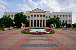
 The Denton County Courts Building, built 1998 | |
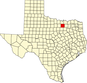
 Location within the U.S. state of Texas | |
 Texas's location within the U.S. | |
| Coordinates: 33°12′N 97°07′W / 33.2°N 97.12°W | |
| Country | |
| State | |
| Founded | April 11, 1846 |
| Named for | John B. Denton |
| Seat | Denton |
| Largest city | Denton |
| Area | |
| • Total | 953 sq mi (2,470 km2) |
| • Land | 878 sq mi (2,270 km2) |
| • Water | 75 sq mi (190 km2) 7.8% |
| Population | |
| • Total | 906,422 |
| • Density | 950/sq mi (370/km2) |
| Time zone | UTC−6 (Central) |
| • Summer (DST) | UTC−5 (CDT) |
| Website | dentoncounty |
Denton County is a county in the U.S. state of Texas. In 2020, 906,422 people lived there.[1] The county seat is Denton.
History[change | change source]
The county was made in 1846. It was named after John B. Denton.
Geography[change | change source]
The county has a total area of 953 square miles.
Schools[change | change source]
These school districts are in Denton County:
- Argyle Independent School District
- Aubrey Independent School District
- Denton Independent School District
- Lake Dallas Independent School District
- Lewisville Independent School District
- Little Elm Independent School District
- Ponder Independent School District
- Sanger Independent School District
Places[change | change source]
Cities[change | change source]
- Argyle
- Aubrey
- Corinth
- Denton (county seat)
- Highland Village
- Little Elm
References[change | change source]
- ↑ 1.0 1.1 "Denton County, Texas". United States Census Bureau. Retrieved August 5, 2023.

