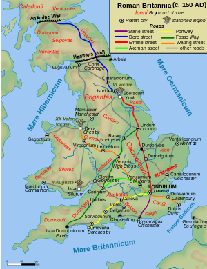
Dere Street
Appearance
| Dere Street | |
|---|---|
 Route of Dere Street in blue | |
| Route information | |
| Length | 226 mi (364 km) |
| Time period | Roman Britain |
| Major junctions | |
| From | Eboracum |
| To | Veluniate |
Dere Street (later Via Regia in Scotland) was a Roman road in Britain. It ran between Eboracum (York) and the Antonine Wall at Bo'ness (Veluniate), in what is now Scotland.
Dere Street still exists as the route of major roads, including the A1 and A68 just north of Corbridge.
Its name comes from the post Roman Anglo-Saxon kingdom of Deira, through which the first part of its route lies. It was sometimes referred to as "Watling Street" and marked on some maps as such. This can cause it to be confused with the Watling Street that linked Dover with Wroxeter.
