
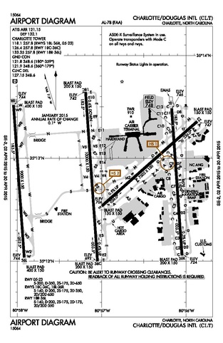
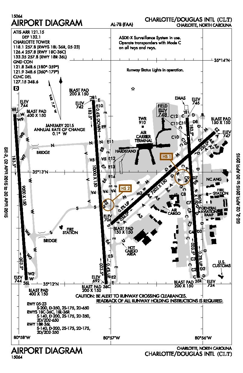
File:CLT Airport Diagram.pdf

Size of this JPG preview of this PDF file: 390 × 599 pixels. Other resolutions: 156 × 240 pixels | 313 × 480 pixels | 806 × 1,237 pixels.
Original file (806 × 1,237 pixels, file size: 250 KB, MIME type: application/pdf)
| This is a file from the Wikimedia Commons. Information from its description page there is shown below. Commons is a freely licensed media file repository. You can help. |

|
File:CLT Airport Diagram.svg is a vector version of this file. It should be used in place of this PDF file when not inferior.
File:CLT Airport Diagram.pdf → File:CLT Airport Diagram.svg
For more information, see Help:SVG. |
 |
Summary
| Description |
English: Airport Diagram of CLT |
| Source | http://www.faa.gov/air_traffic/flight_info/aeronav/digital_products/dtpp/search/results/ |
| Author | Federal Aviation Administration |
- Other information
English: There is a new hotspot at the intersection of Taxiway S and E5
This image or file is a work of a Federal Aviation Administration employee, taken or made as part of that person's official duties. As a work of the U.S. federal government, the image is in the public domain in the United States.
|
 |
Licensing
This image or file is a work of a Federal Aviation Administration employee, taken or made as part of that person's official duties. As a work of the U.S. federal government, the image is in the public domain in the United States.
|
|
File history
Click on a date/time to view the file as it appeared at that time.
| Date/Time | Thumbnail | Dimensions | User | Comment | |
|---|---|---|---|---|---|
| current | 19:31, 3 April 2015 |  | 806 × 1,237 (250 KB) | Sam.gov | {{subst:Upload marker added by en.wp UW}} {{Information |Description = {{en|Airport Diagram of CLT}} |Source = http://www.faa.gov/air_traffic/flight_info/aeronav/digital_products/dtpp/search/results/ |Author = Federal Aviation Administration }} ;Other... |
File usage
The following page uses this file:
Global file usage
The following other wikis use this file:
- Usage on ur.wikipedia.org