
File:Pusan Perimeter.jpg
No higher resolution available.
Pusan_Perimeter.jpg (350 × 572 pixels, file size: 52 KB, MIME type: image/jpeg)
| This is a file from the Wikimedia Commons. Information from its description page there is shown below. Commons is a freely licensed media file repository. You can help. |
Summary
| Description |
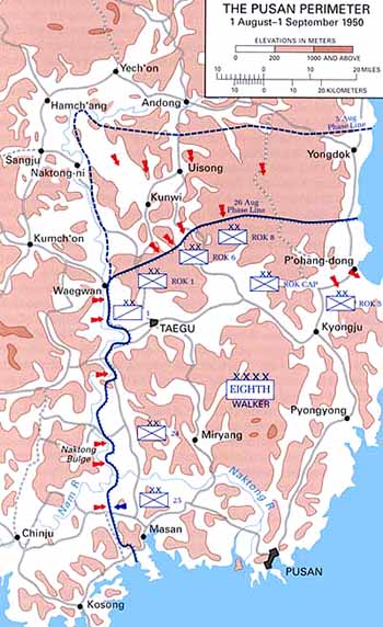
English: Map of the Pusan Perimeter, August 1950. |
| Source | This map was created by the Center for Military History and used in the brochure "The Korean War: The Outbreak" located at [1]. |
| Author | United States Army Center of Military History |
| Other versions |
|
.jpg)
.jpg)
.jpg)
.jpg)
.jpg)
Licensing
| This image is in the public domain because it contains materials that originally came from the United States Army Center of Military History, subject to the following qualification.
Note: The images of all badges, insignia, decorations and medals on the "CMH Online" web site are produced by the United States Army Institute of Heraldry and protected by Title 18, United States Code, Section 704 and the Code of Federal Regulations (32 CFR, Part 507). Permission to use these images for commercial purposes must be obtained from The Institute of Heraldry prior to their use. |

|
Original upload log
The original description page was here. All following user names refer to en.wikipedia.
File history
Click on a date/time to view the file as it appeared at that time.
| Date/Time | Thumbnail | Dimensions | User | Comment | |
|---|---|---|---|---|---|
| current | 01:13, 15 March 2008 | | 350 × 572 (52 KB) | Donostiarra~commonswiki | {{Information |Description={{en|Map of the Pusan Perimeter, August 1950. This map was created by the Center for Military History and used in the brochure "The Korean War: The Outbreak" located at [http://www.army.mil/cmh-pg/brochures/KW-Outbreak/outbreak. |
File usage
The following 2 pages use this file:
Global file usage
The following other wikis use this file:
- Usage on ar.wikipedia.org
- Usage on cs.wikipedia.org
- Usage on de.wikipedia.org
- Usage on en.wikipedia.org
- Usage on es.wikipedia.org
- Usage on fr.wikipedia.org
- Usage on he.wikipedia.org
- Usage on ko.wikipedia.org
- Usage on no.wikipedia.org
- Usage on pl.wikipedia.org
- Usage on pt.wikipedia.org
- Usage on ru.wikipedia.org
- Usage on uk.wikipedia.org
- Usage on vi.wikipedia.org