
File:SGMRT-LRT map.svg

Size of this PNG preview of this SVG file: 800 × 448 pixels. Other resolutions: 320 × 179 pixels | 640 × 358 pixels | 1,024 × 573 pixels | 1,280 × 717 pixels | 2,560 × 1,433 pixels | 2,799 × 1,567 pixels.
Original file (SVG file, nominally 2,799 × 1,567 pixels, file size: 439 KB)
| This is a file from the Wikimedia Commons. Information from its description page there is shown below. Commons is a freely licensed media file repository. You can help. |
Summary
| Description |
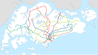
English: Shows all announced lines with confirmed stations. |
| Date | |
| Source | Own work |
| Author | Map of Singapore and line layouts are taken from OpenStreetMap contributors Cleanup and editing by Seloloving. |
| SVG development |
Licensing
This file is licensed under the Creative Commons Attribution-Share Alike 2.0 Generic license.
- You are free:
- to share – to copy, distribute and transmit the work
- to remix – to adapt the work
- Under the following conditions:
- attribution – You must give appropriate credit, provide a link to the license, and indicate if changes were made. You may do so in any reasonable manner, but not in any way that suggests the licensor endorses you or your use.
- share alike – If you remix, transform, or build upon the material, you must distribute your contributions under the same or compatible license as the original.
File history
Click on a date/time to view the file as it appeared at that time.
| Date/Time | Thumbnail | Dimensions | User | Comment | |
|---|---|---|---|---|---|
| current | 00:51, 21 September 2022 | | 2,799 × 1,567 (439 KB) | Seloloving | CRL2 |
| 10:27, 8 October 2021 |  | 2,799 × 1,567 (437 KB) | Seloloving | Accurate alignment for CRL | |
| 07:20, 19 July 2020 |  | 2,799 × 1,567 (437 KB) | Seloloving | fixed errors | |
| 15:27, 15 July 2020 |  | 2,799 × 1,566 (535 KB) | Seloloving | Updated map | |
| 05:22, 15 July 2020 |  | 1,709 × 977 (301 KB) | Seloloving | added CRL PE | |
| 11:08, 18 June 2020 |  | 2,834 × 1,580 (324 KB) | Seloloving | replacement map for all pages | |
| 13:46, 15 June 2020 |  | 1,709 × 977 (300 KB) | Seloloving | Reverted to version as of 10:05, 10 January 2020 (UTC) | |
| 13:45, 15 June 2020 |  | 2,827 × 1,644 (325 KB) | Seloloving | updated island | |
| 10:05, 10 January 2020 |  | 1,709 × 977 (300 KB) | Seloloving | missing bplrt. | |
| 17:21, 9 January 2020 |  | 1,709 × 977 (300 KB) | Seloloving | added new lines with confirmed stations. |
File usage
The following 15 pages use this file:
- Bright Hill MRT station
- Bukit Panjang MRT/LRT station
- Changi Airport MRT station
- Clementi MRT station
- Expo MRT station
- Joo Koon MRT station
- Lentor MRT station
- Mayflower MRT station
- Outline of Singapore
- Pioneer MRT station
- Simei MRT station
- Springleaf MRT station
- Tuas Crescent MRT station
- Woodlands MRT station
- Woodlands North MRT station
Global file usage
The following other wikis use this file:
- Usage on de.wikipedia.org
- Usage on en.wikipedia.org
- Jurong East MRT station
- Bishan MRT station
- Changi Airport MRT station
- Boon Lay MRT station
- Pasir Ris MRT station
- Simei MRT station
- Ang Mo Kio MRT station
- Light Rail Transit (Singapore)
- Tampines MRT station
- Dover MRT station
- Expo MRT station
- Clementi MRT station
- Bukit Batok MRT station
- Buangkok MRT station
- Kovan MRT station
- Hougang MRT station
- Tanah Merah MRT station
- Sembawang MRT station
- Yishun MRT station
- Braddell MRT station
- Bukit Gombak MRT station
- Yew Tee MRT station
- Kranji MRT station
- Marsiling MRT station
- Woodlands MRT station
- Admiralty MRT station
- Khatib MRT station
- Yio Chu Kang MRT station
- Bedok MRT station
- Kembangan MRT station
- Eunos MRT station
- Kallang MRT station
- Chinese Garden MRT station
- Lakeside MRT station
- Pioneer MRT station
- Joo Koon MRT station
- Marymount MRT station
- Riviera MRT/LRT station
- Portal:Transport/Selected article
- Jurong West MRT station
- Outline of Singapore
- King Albert Park MRT station
- Beauty World MRT station
- Hillview MRT station
- Cashew MRT station
- Bukit Panjang MRT/LRT station
- User:Seloloving
- Ubi MRT station
- Kaki Bukit MRT station
View more global usage of this file.