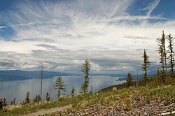
Flathead Lake
| Flathead Lake | |
|---|---|
 | |
| Location | Montana |
| Coordinates | 47°54′6″N 114°6′15″W / 47.90167°N 114.10417°W |
| Type | Moraine-dammed lake |
| Primary inflows | Flathead River Swan River |
| Primary outflows | Flathead River |
| Catchment area | 8,587 square miles (22,240 km2) |
| Basin countries | United States |
| Max. length | 27.3 mi (43.9 km) |
| Max. width | 15.5 mi (24.9 km) |
| Surface area | 191.5 sq mi (496 km2) |
| Average depth | 164.7 ft (50.2 m) |
| Max. depth | 370.7 ft (113.0 m) |
| Water volume | 5.56 cu mi (23.2 km3) |
| Residence time | 3.4 years |
| Shore length1 | 161.4 mi (259.7 km) |
| Surface elevation | 2,894 ft (882 m) |
| Islands | Wild Horse Island, Cromwell, Bird, Bull, Melita, Shelter, Cedar, Mother-in-Law, Dream, etc. |
| 1 Shore length is not a well-defined measure. | |
Flathead Lake is a lake in Montana. It covers 197 square miles (510 km2).
Wikimedia Commons has media related to Flathead Lake.
