Gowanda, New York
Appearance
Gowanda, New York | |
|---|---|
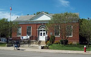
 U.S. Post Office, Gowanda, NY, August 2010 | |
 Location in Erie County, New York. | |
| Coordinates: 42°27′48″N 78°56′11″W / 42.46333°N 78.93639°W | |
| Country | United States |
| State | New York |
| Counties | Cattaraugus, Erie |
| Towns | Persia, Collins |
| Area | |
| • Total | 1.61 sq mi (4.17 km2) |
| • Land | 1.59 sq mi (4.13 km2) |
| • Water | 0.02 sq mi (0.04 km2) |
| Elevation | 761 ft (232 m) |
| Population | |
| • Total | 2,513 |
| • Density | 1,577.53/sq mi (609.09/km2) |
| Time zone | UTC-5 (Eastern (EST)) |
| • Summer (DST) | UTC-4 (EDT) |
| ZIP code | 14070 |
| Area code | 716 |
| FIPS code | 36-29630 |
| GNIS feature ID | 0951430 |
| Website | villageofgowanda |
Gowanda is a village in western New York, United States. It is partly in Erie County and partly in Cattaraugus County. 2,513 people lived there at the 2020 census.[2] The name comes from the Seneca language. It means "almost surrounded by hills" or "a valley among the hills". The Cattaraugus Reservation is next to the village. The natives here are mainly Seneca people. [3]
Native Americans of the Iroquois Confederacy used to live in the larger area of western New York. The Erie tribe and the Wenrohronon lived the closest to present-day area around Gowanda.[4]
References
[change | change source]- ↑ "2020 U.S. Gazetteer Files". United States Census Bureau. Retrieved August 16, 2024.
- ↑ 2.0 2.1 "DP1: PROFILE OF GENERAL POPULATION AND HOUSING CHARACTERISTICS". United States Census Bureau. Retrieved August 16, 2024.
- ↑ Bureau, US Census. "City and Town Population Totals: 2020-2021". Census.gov. US Census Bureau. Retrieved August 19, 2022.
- ↑ "Native American Tribes of New York". History of American Women. 2008-05-19. Retrieved 2022-08-19.


