Granite Falls, Minnesota
Granite Falls, Minnesota | |
|---|---|
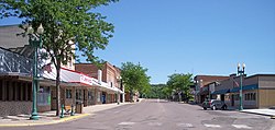
 Prentice Street in downtown Granite Falls in 2007 | |
 Location of Granite Falls within Yellow Medicine County, Minnesota | |
| Coordinates: 44°48′38″N 95°32′17″W / 44.81056°N 95.53806°W | |
| Country | United States |
| State | Minnesota |
| Counties | Chippewa, Yellow Medicine |
| village | 1879 |
| incorporated | April 24, 1889 |
| Area | |
| • Total | 3.73 sq mi (9.66 km2) |
| • Land | 3.49 sq mi (9.05 km2) |
| • Water | 0.24 sq mi (0.61 km2) |
| Elevation | 906 ft (276 m) |
| Population | |
| • Total | 2,737 |
| • Density | 783.34/sq mi (302.48/km2) |
| Time zone | UTC-6 (CST) |
| • Summer (DST) | UTC-5 (CDT) |
| ZIP code | 56241 |
| Area code | 320 |
| FIPS code | 27-25280[4] |
| GNIS feature ID | 2394962[2] |
| Website | granitefalls.com |
Granite Falls is a city in Chippewa and Yellow Medicine counties in the State of Minnesota. The population was 2,737 at the 2020 census.[3] It is the county seat of Yellow Medicine County.[5]
References[change | change source]
- ↑ "2020 U.S. Gazetteer Files". United States Census Bureau. Retrieved July 24, 2022.
- ↑ 2.0 2.1 U.S. Geological Survey Geographic Names Information System: Granite Falls, Minnesota
- ↑ 3.0 3.1 "Profile of General Population and Housing Characteristics: 2020 Demographic Profile Data (DP-1): Granite Falls city, Minnesota". United States Census Bureau. Retrieved February 21, 2024.
- ↑ "U.S. Census website". United States Census Bureau. Retrieved January 31, 2008.
- ↑ National Association of Counties. "NACo County Explorer". Retrieved February 21, 2024.

